You are here: Home > Network List > O2 - Oklahoma Consolidated Temporary Seismic Networks Stations List
> Station FW01 Cuddy Creek, Oklahoma, USA > Earthquake Result Viewer
FW01 Cuddy Creek, Oklahoma, USA - Earthquake Result Viewer
| Earthquake location: |
Northwestern Balkan Region |
| Earthquake latitude/longitude: |
45.4/16.3 |
| Earthquake time(UTC): |
2020/12/29 (364) 11:19:54 GMT |
| Earthquake Depth: |
10 km |
| Earthquake Magnitude: |
6.4 mww |
| Earthquake Catalog/Contributor: |
NEIC PDE/us |
|
| Network: |
O2 Oklahoma Consolidated Temporary Seismic Networks |
| Station: |
FW01 Cuddy Creek, Oklahoma, USA |
| Lat/Lon: |
36.49 N/98.94 W |
| Elevation: |
431 m |
|
| Distance: |
79.7 deg |
| Az: |
312.203 deg |
| Baz: |
40.355 deg |
| Ray Param: |
0.048762508 |
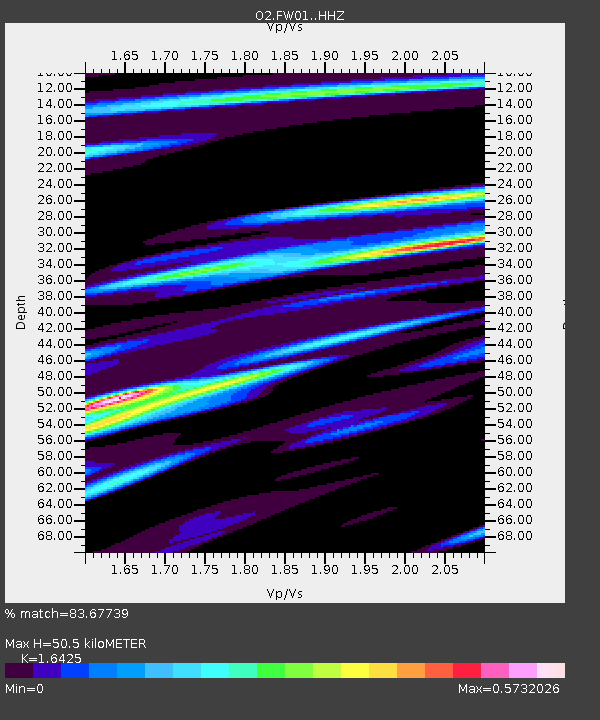
| Estimated Moho Depth: |
50.5 km |
| Estimated Crust Vp/Vs: |
1.64 |
| Assumed Crust Vp: |
6.426 km/s |
| Estimated Crust Vs: |
3.912 km/s |
| Estimated Crust Poisson's Ratio: |
0.21 |
|
| Radial Match: |
83.67739 % |
| Radial Bump: |
355 |
| Transverse Match: |
64.27154 % |
| Transverse Bump: |
400 |
| SOD ConfigId: |
23341671 |
| Insert Time: |
2021-01-12 12:37:37.182 +0000 |
| GWidth: |
2.5 |
| Max Bumps: |
400 |
| Tol: |
0.001 |
|

Signal To Noise
| Channel | StoN | STA | LTA |
| O2:FW01: :HHZ:20201229T11:31:31.414993Z | 2.6311965 | 5.8870916E-7 | 2.2374199E-7 |
| O2:FW01: :HHN:20201229T11:31:31.414993Z | 1.0972592 | 2.6865214E-7 | 2.4483927E-7 |
| O2:FW01: :HHE:20201229T11:31:31.414993Z | 1.8145149 | 3.0768746E-7 | 1.695701E-7 |
| Arrivals |
| Ps | 5.2 SECOND |
| PpPs | 20 SECOND |
| PsPs/PpSs | 25 SECOND |


