You are here: Home > Network List > GE - GEOFON Stations List
> Station CSS GEOFON/GII Station Mathiatis, Cyprus > Earthquake Result Viewer
CSS GEOFON/GII Station Mathiatis, Cyprus - Earthquake Result Viewer
| Earthquake location: |
Northern Molucca Sea |
| Earthquake latitude/longitude: |
0.8/126.0 |
| Earthquake time(UTC): |
2001/10/13 (286) 16:27:00 GMT |
| Earthquake Depth: |
33 km |
| Earthquake Magnitude: |
5.6 MB, 5.7 MS, 6.0 MW, 5.8 MW |
| Earthquake Catalog/Contributor: |
WHDF/NEIC |
|
| Network: |
GE GEOFON |
| Station: |
CSS GEOFON/GII Station Mathiatis, Cyprus |
| Lat/Lon: |
34.96 N/33.33 E |
| Elevation: |
396 m |
|
| Distance: |
91.7 deg |
| Az: |
304.832 deg |
| Baz: |
87.804 deg |
| Ray Param: |
0.041561678 |
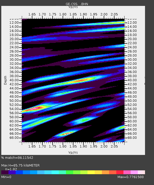
| Estimated Moho Depth: |
65.75 km |
| Estimated Crust Vp/Vs: |
1.82 |
| Assumed Crust Vp: |
5.782 km/s |
| Estimated Crust Vs: |
3.177 km/s |
| Estimated Crust Poisson's Ratio: |
0.28 |
|
| Radial Match: |
86.11542 % |
| Radial Bump: |
400 |
| Transverse Match: |
89.65061 % |
| Transverse Bump: |
400 |
| SOD ConfigId: |
20082 |
| Insert Time: |
2010-03-09 04:27:31.708 +0000 |
| GWidth: |
2.5 |
| Max Bumps: |
400 |
| Tol: |
0.001 |
|

Signal To Noise
| Channel | StoN | STA | LTA |
| GE:CSS: :BHN:20011013T16:39:32.812004Z | 1.1595414 | 5.6841284E-8 | 4.902049E-8 |
| GE:CSS: :BHE:20011013T16:39:32.812004Z | 2.404758 | 1.3022097E-7 | 5.4151386E-8 |
| GE:CSS: :BHZ:20011013T16:39:32.812004Z | 3.1692839 | 2.5613966E-7 | 8.081941E-8 |
| Arrivals |
| Ps | 9.5 SECOND |
| PpPs | 32 SECOND |
| PsPs/PpSs | 41 SECOND |


