You are here: Home > Network List > O2 - Oklahoma Consolidated Temporary Seismic Networks Stations List
> Station PW13 Pawnee, Oklahoma, USA > Earthquake Result Viewer
PW13 Pawnee, Oklahoma, USA - Earthquake Result Viewer
| Earthquake location: |
Northwestern Balkan Region |
| Earthquake latitude/longitude: |
45.4/16.3 |
| Earthquake time(UTC): |
2020/12/29 (364) 11:19:54 GMT |
| Earthquake Depth: |
10 km |
| Earthquake Magnitude: |
6.4 mww |
| Earthquake Catalog/Contributor: |
NEIC PDE/us |
|
| Network: |
O2 Oklahoma Consolidated Temporary Seismic Networks |
| Station: |
PW13 Pawnee, Oklahoma, USA |
| Lat/Lon: |
36.33 N/96.82 W |
| Elevation: |
290 m |
|
| Distance: |
78.7 deg |
| Az: |
310.774 deg |
| Baz: |
41.343 deg |
| Ray Param: |
0.04944454 |
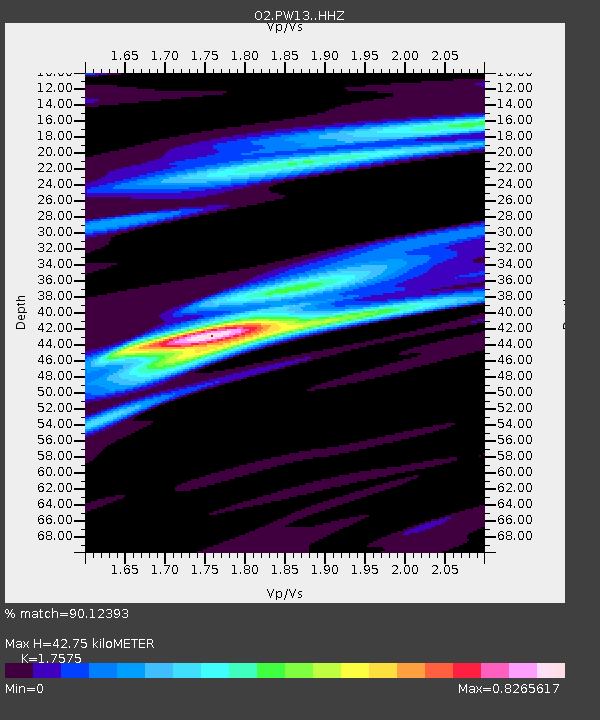
| Estimated Moho Depth: |
42.75 km |
| Estimated Crust Vp/Vs: |
1.76 |
| Assumed Crust Vp: |
6.483 km/s |
| Estimated Crust Vs: |
3.689 km/s |
| Estimated Crust Poisson's Ratio: |
0.26 |
|
| Radial Match: |
90.12393 % |
| Radial Bump: |
400 |
| Transverse Match: |
70.12853 % |
| Transverse Bump: |
400 |
| SOD ConfigId: |
23341671 |
| Insert Time: |
2021-01-12 12:38:04.630 +0000 |
| GWidth: |
2.5 |
| Max Bumps: |
400 |
| Tol: |
0.001 |
|

Signal To Noise
| Channel | StoN | STA | LTA |
| O2:PW13: :HHZ:20201229T11:31:26.000015Z | 1.5196152 | 1.4057695E-6 | 9.2508253E-7 |
| O2:PW13: :HHN:20201229T11:31:26.000015Z | 1.3065076 | 2.1778228E-6 | 1.6669042E-6 |
| O2:PW13: :HHE:20201229T11:31:26.000015Z | 1.1972318 | 1.6677805E-6 | 1.3930305E-6 |
| Arrivals |
| Ps | 5.1 SECOND |
| PpPs | 18 SECOND |
| PsPs/PpSs | 23 SECOND |


