You are here: Home > Network List > O2 - Oklahoma Consolidated Temporary Seismic Networks Stations List
> Station SMNL Seminole, Oklahoma, USA > Earthquake Result Viewer
SMNL Seminole, Oklahoma, USA - Earthquake Result Viewer
| Earthquake location: |
Northwestern Balkan Region |
| Earthquake latitude/longitude: |
45.4/16.3 |
| Earthquake time(UTC): |
2020/12/29 (364) 11:19:54 GMT |
| Earthquake Depth: |
10 km |
| Earthquake Magnitude: |
6.4 mww |
| Earthquake Catalog/Contributor: |
NEIC PDE/us |
|
| Network: |
O2 Oklahoma Consolidated Temporary Seismic Networks |
| Station: |
SMNL Seminole, Oklahoma, USA |
| Lat/Lon: |
35.29 N/96.56 W |
| Elevation: |
317 m |
|
| Distance: |
79.4 deg |
| Az: |
309.923 deg |
| Baz: |
41.329 deg |
| Ray Param: |
0.04901097 |
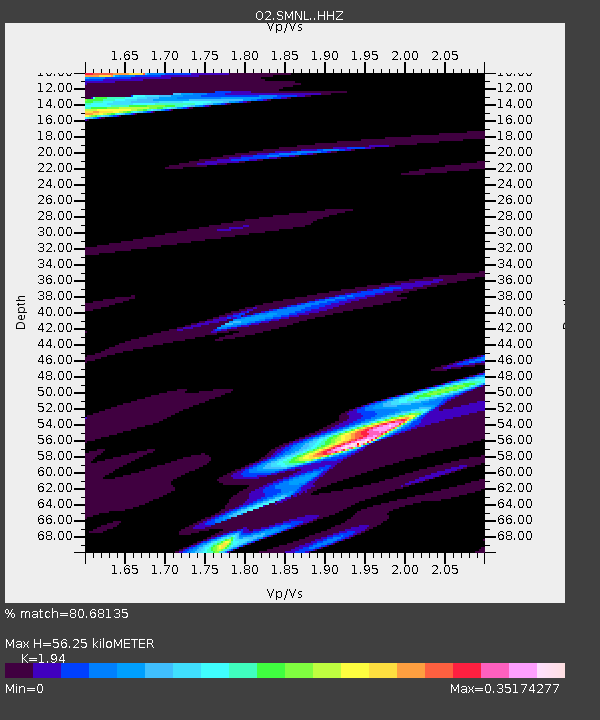
| Estimated Moho Depth: |
56.25 km |
| Estimated Crust Vp/Vs: |
1.94 |
| Assumed Crust Vp: |
6.426 km/s |
| Estimated Crust Vs: |
3.312 km/s |
| Estimated Crust Poisson's Ratio: |
0.32 |
|
| Radial Match: |
80.68135 % |
| Radial Bump: |
400 |
| Transverse Match: |
63.048462 % |
| Transverse Bump: |
400 |
| SOD ConfigId: |
23341671 |
| Insert Time: |
2021-01-12 12:38:37.343 +0000 |
| GWidth: |
2.5 |
| Max Bumps: |
400 |
| Tol: |
0.001 |
|

Signal To Noise
| Channel | StoN | STA | LTA |
| O2:SMNL: :HHZ:20201229T11:31:29.490005Z | 4.831586 | 7.652991E-7 | 1.5839501E-7 |
| O2:SMNL: :HHN:20201229T11:31:29.490005Z | 2.425932 | 3.8088362E-7 | 1.5700508E-7 |
| O2:SMNL: :HHE:20201229T11:31:29.490005Z | 0.75032705 | 1.607069E-7 | 2.1418246E-7 |
| Arrivals |
| Ps | 8.4 SECOND |
| PpPs | 25 SECOND |
| PsPs/PpSs | 34 SECOND |


