You are here: Home > Network List > GE - GEOFON Stations List
> Station CSS GEOFON/GII Station Mathiatis, Cyprus > Earthquake Result Viewer
CSS GEOFON/GII Station Mathiatis, Cyprus - Earthquake Result Viewer
| Earthquake location: |
Kuril Islands |
| Earthquake latitude/longitude: |
44.1/148.1 |
| Earthquake time(UTC): |
2001/03/23 (082) 11:30:10 GMT |
| Earthquake Depth: |
33 km |
| Earthquake Magnitude: |
5.9 MB, 5.7 MS, 6.0 MW, 5.9 MW |
| Earthquake Catalog/Contributor: |
WHDF/NEIC |
|
| Network: |
GE GEOFON |
| Station: |
CSS GEOFON/GII Station Mathiatis, Cyprus |
| Lat/Lon: |
34.96 N/33.33 E |
| Elevation: |
396 m |
|
| Distance: |
81.5 deg |
| Az: |
311.032 deg |
| Baz: |
41.453 deg |
| Ray Param: |
0.04749683 |
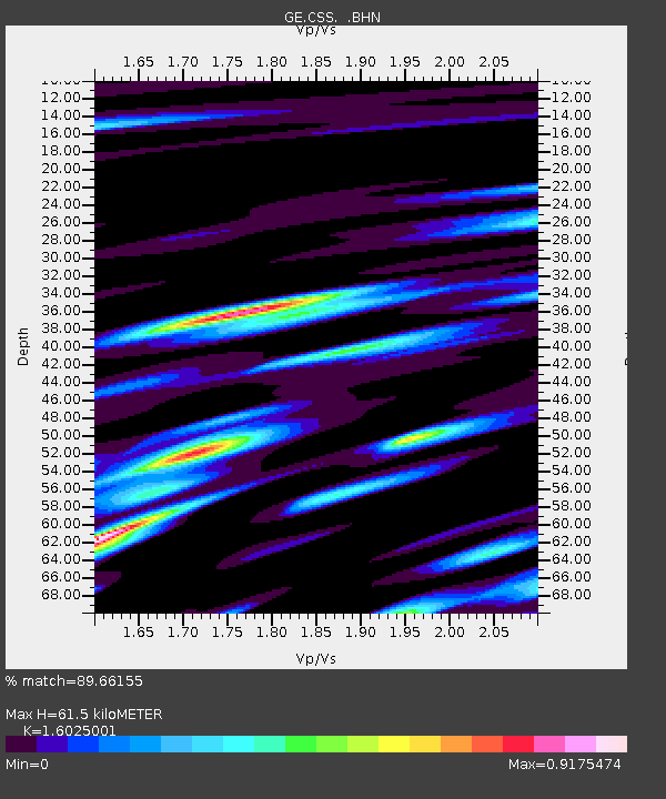
| Estimated Moho Depth: |
61.5 km |
| Estimated Crust Vp/Vs: |
1.60 |
| Assumed Crust Vp: |
5.782 km/s |
| Estimated Crust Vs: |
3.608 km/s |
| Estimated Crust Poisson's Ratio: |
0.18 |
|
| Radial Match: |
89.66155 % |
| Radial Bump: |
400 |
| Transverse Match: |
86.585304 % |
| Transverse Bump: |
400 |
| SOD ConfigId: |
4714 |
| Insert Time: |
2010-03-09 04:27:45.064 +0000 |
| GWidth: |
2.5 |
| Max Bumps: |
400 |
| Tol: |
0.001 |
|

Signal To Noise
| Channel | StoN | STA | LTA |
| GE:CSS: :BHN:20010323T11:41:53.460002Z | 4.4682107 | 6.990181E-7 | 1.564425E-7 |
| GE:CSS: :BHE:20010323T11:41:53.460002Z | 4.163076 | 6.4109537E-7 | 1.5399559E-7 |
| GE:CSS: :BHZ:20010323T11:41:53.460002Z | 16.193478 | 1.7719562E-6 | 1.09424064E-7 |
| Arrivals |
| Ps | 6.6 SECOND |
| PpPs | 27 SECOND |
| PsPs/PpSs | 34 SECOND |


