You are here: Home > Network List > TA - USArray Transportable Network (new EarthScope stations) Stations List
> Station H31M Peel River, Yukon, CAN > Earthquake Result Viewer
H31M Peel River, Yukon, CAN - Earthquake Result Viewer
| Earthquake location: |
Northwestern Balkan Region |
| Earthquake latitude/longitude: |
45.4/16.3 |
| Earthquake time(UTC): |
2020/12/29 (364) 11:19:54 GMT |
| Earthquake Depth: |
10 km |
| Earthquake Magnitude: |
6.4 mww |
| Earthquake Catalog/Contributor: |
NEIC PDE/us |
|
| Network: |
TA USArray Transportable Network (new EarthScope stations) |
| Station: |
H31M Peel River, Yukon, CAN |
| Lat/Lon: |
65.81 N/134.34 W |
| Elevation: |
642 m |
|
| Distance: |
66.8 deg |
| Az: |
347.302 deg |
| Baz: |
22.068 deg |
| Ray Param: |
0.057369526 |
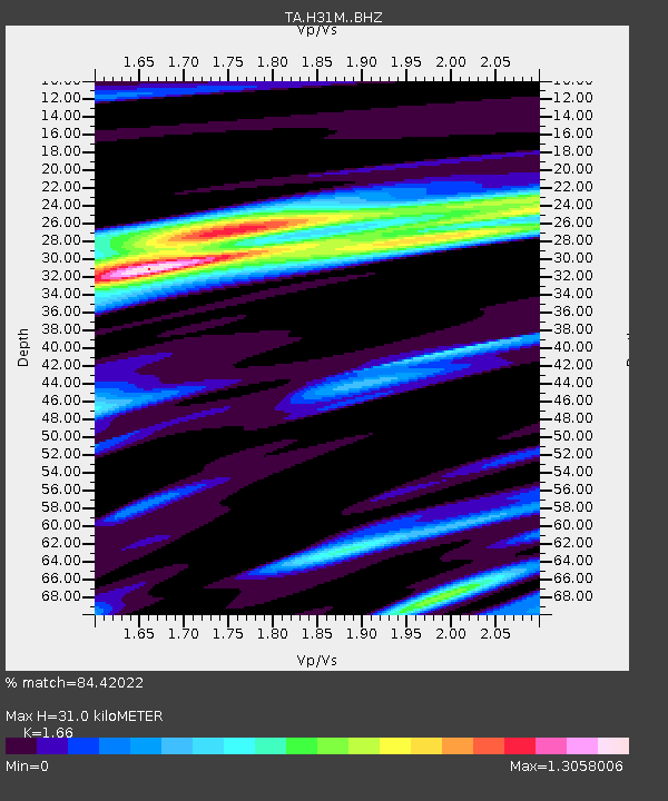
| Estimated Moho Depth: |
31.0 km |
| Estimated Crust Vp/Vs: |
1.66 |
| Assumed Crust Vp: |
6.419 km/s |
| Estimated Crust Vs: |
3.867 km/s |
| Estimated Crust Poisson's Ratio: |
0.22 |
|
| Radial Match: |
84.42022 % |
| Radial Bump: |
363 |
| Transverse Match: |
66.41547 % |
| Transverse Bump: |
400 |
| SOD ConfigId: |
23341671 |
| Insert Time: |
2021-01-12 12:42:11.204 +0000 |
| GWidth: |
2.5 |
| Max Bumps: |
400 |
| Tol: |
0.001 |
|
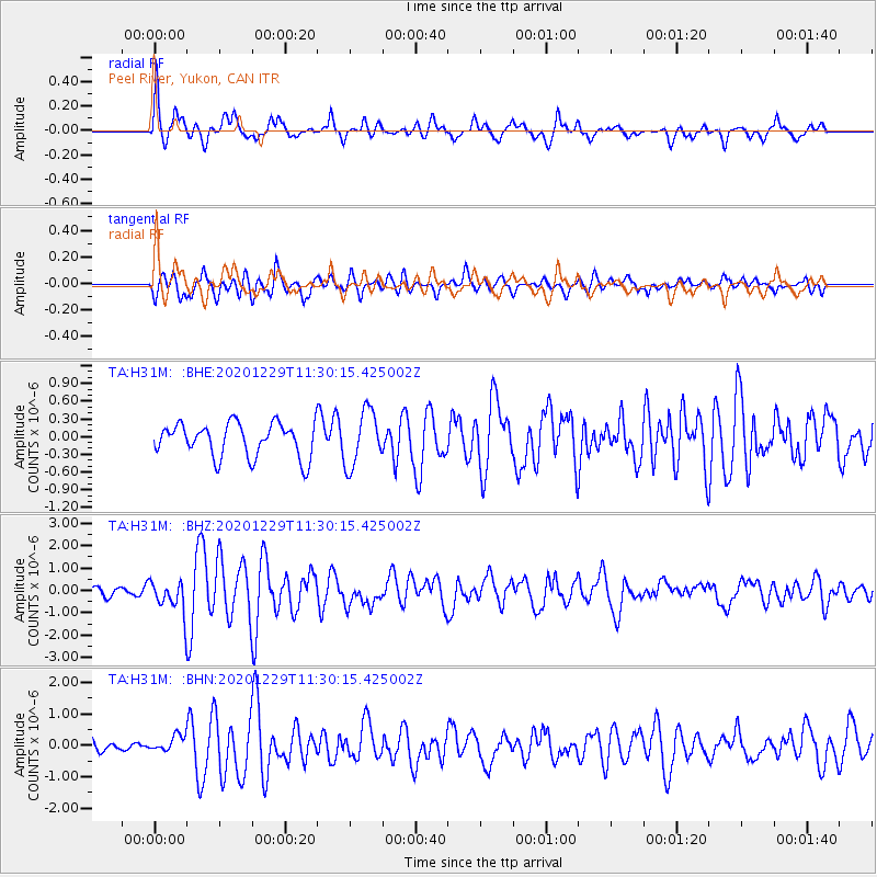
Signal To Noise
| Channel | StoN | STA | LTA |
| TA:H31M: :BHZ:20201229T11:30:15.425002Z | 3.5783305 | 7.662635E-7 | 2.1413993E-7 |
| TA:H31M: :BHN:20201229T11:30:15.425002Z | 1.0277752 | 2.5783223E-7 | 2.5086445E-7 |
| TA:H31M: :BHE:20201229T11:30:15.425002Z | 1.6426926 | 4.6736997E-7 | 2.8451458E-7 |
| Arrivals |
| Ps | 3.3 SECOND |
| PpPs | 12 SECOND |
| PsPs/PpSs | 16 SECOND |


