You are here: Home > Network List > GE - GEOFON Stations List
> Station CSS GEOFON/GII Station Mathiatis, Cyprus > Earthquake Result Viewer
CSS GEOFON/GII Station Mathiatis, Cyprus - Earthquake Result Viewer
| Earthquake location: |
Northwest Of Kuril Islands |
| Earthquake latitude/longitude: |
52.8/153.8 |
| Earthquake time(UTC): |
2001/02/07 (038) 15:16:15 GMT |
| Earthquake Depth: |
427 km |
| Earthquake Magnitude: |
5.6 MB, 5.8 MW, 5.7 MW |
| Earthquake Catalog/Contributor: |
WHDF/NEIC |
|
| Network: |
GE GEOFON |
| Station: |
CSS GEOFON/GII Station Mathiatis, Cyprus |
| Lat/Lon: |
34.96 N/33.33 E |
| Elevation: |
396 m |
|
| Distance: |
78.5 deg |
| Az: |
313.774 deg |
| Baz: |
32.303 deg |
| Ray Param: |
0.048379656 |
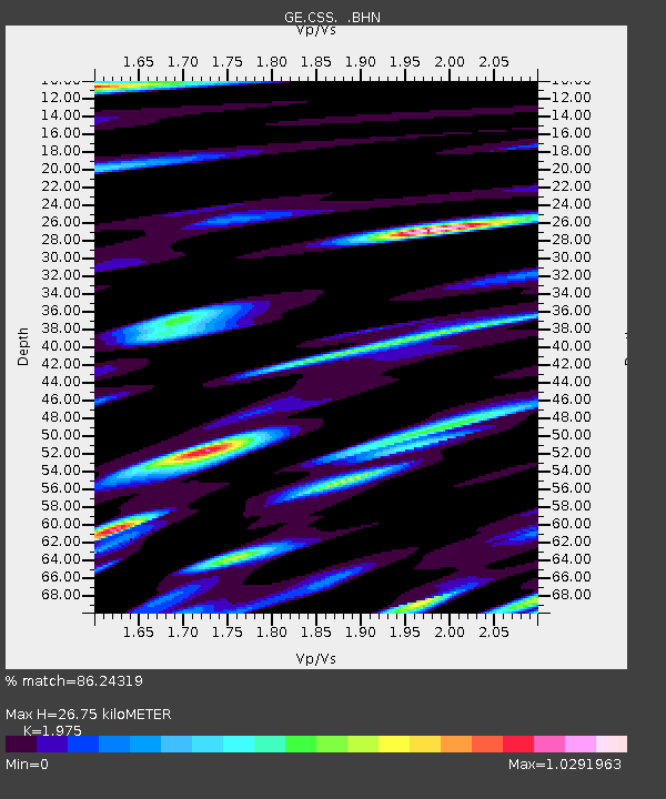
| Estimated Moho Depth: |
26.75 km |
| Estimated Crust Vp/Vs: |
1.98 |
| Assumed Crust Vp: |
5.782 km/s |
| Estimated Crust Vs: |
2.928 km/s |
| Estimated Crust Poisson's Ratio: |
0.33 |
|
| Radial Match: |
86.24319 % |
| Radial Bump: |
400 |
| Transverse Match: |
82.24784 % |
| Transverse Bump: |
400 |
| SOD ConfigId: |
3753 |
| Insert Time: |
2010-03-09 04:28:09.628 +0000 |
| GWidth: |
2.5 |
| Max Bumps: |
400 |
| Tol: |
0.001 |
|

Signal To Noise
| Channel | StoN | STA | LTA |
| GE:CSS: :BHN:20010207T15:26:59.693022Z | 6.614488 | 5.5302183E-7 | 8.360766E-8 |
| GE:CSS: :BHE:20010207T15:26:59.693022Z | 10.293466 | 8.565354E-7 | 8.321157E-8 |
| GE:CSS: :BHZ:20010207T15:26:59.693022Z | 21.021904 | 1.942852E-6 | 9.242036E-8 |
| Arrivals |
| Ps | 4.6 SECOND |
| PpPs | 13 SECOND |
| PsPs/PpSs | 18 SECOND |


