You are here: Home > Network List > TX - Texas Seismological Network Stations List
> Station MB04 Seminole > Earthquake Result Viewer
MB04 Seminole - Earthquake Result Viewer
| Earthquake location: |
Northwestern Balkan Region |
| Earthquake latitude/longitude: |
45.4/16.3 |
| Earthquake time(UTC): |
2020/12/29 (364) 11:19:54 GMT |
| Earthquake Depth: |
10 km |
| Earthquake Magnitude: |
6.4 mww |
| Earthquake Catalog/Contributor: |
NEIC PDE/us |
|
| Network: |
TX Texas Seismological Network |
| Station: |
MB04 Seminole |
| Lat/Lon: |
32.63 N/102.49 W |
| Elevation: |
956 m |
|
| Distance: |
84.6 deg |
| Az: |
312.02 deg |
| Baz: |
38.326 deg |
| Ray Param: |
0.045393858 |
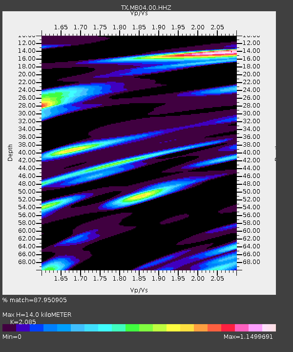
| Estimated Moho Depth: |
14.0 km |
| Estimated Crust Vp/Vs: |
2.09 |
| Assumed Crust Vp: |
6.129 km/s |
| Estimated Crust Vs: |
2.94 km/s |
| Estimated Crust Poisson's Ratio: |
0.35 |
|
| Radial Match: |
87.950905 % |
| Radial Bump: |
323 |
| Transverse Match: |
56.47686 % |
| Transverse Bump: |
400 |
| SOD ConfigId: |
23341671 |
| Insert Time: |
2021-01-12 12:43:39.680 +0000 |
| GWidth: |
2.5 |
| Max Bumps: |
400 |
| Tol: |
0.001 |
|

Signal To Noise
| Channel | StoN | STA | LTA |
| TX:MB04:00:HHZ:20201229T11:31:56.690017Z | 4.351416 | 2.1823627E-7 | 5.015293E-8 |
| TX:MB04:00:HH1:20201229T11:31:56.690017Z | 1.540776 | 9.54567E-8 | 6.195365E-8 |
| TX:MB04:00:HH2:20201229T11:31:56.690017Z | 1.9058477 | 9.010613E-8 | 4.7278764E-8 |
| Arrivals |
| Ps | 2.5 SECOND |
| PpPs | 6.9 SECOND |
| PsPs/PpSs | 9.4 SECOND |


