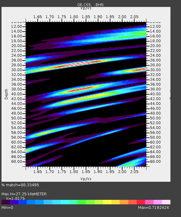
CSS GEOFON/GII Station Mathiatis, Cyprus - Earthquake Result Viewer

Earthquake location: Southern Sumatra, Indonesia
Earthquake latitude/longitude: -5.8/102.1
Earthquake time(UTC): 2002/05/23 (143) 22:05:51 GMT
Earthquake Depth: 10 km
Earthquake Magnitude: 5.5 MB, 5.4 MS, 5.6 MW, 5.4 MW
Earthquake Catalog/Contributor: WHDF/NEIC
Network: GE GEOFON
Station: CSS GEOFON/GII Station Mathiatis, Cyprus
Lat/Lon: 34.96 N/33.33 E
Elevation: 396 m
Distance: 76.2 deg
Az: 307.978 deg
Baz: 107.286 deg
Ray Param: 0.05117183
Estimated Moho Depth: 27.25 km
Estimated Crust Vp/Vs: 1.82
Assumed Crust Vp: 5.782 km/s
Estimated Crust Vs: 3.181 km/s
Estimated Crust Poisson's Ratio: 0.28
Radial Match: 88.33495 %
Radial Bump: 400
Transverse Match: 81.02696 %
Transverse Bump: 400
SOD ConfigId: 20082
Insert Time: 2010-03-09 04:28:28.510 +0000
GWidth: 2.5
Max Bumps: 400
Tol: 0.001

Signal To Noise

ChannelStoNSTALTA
GE:CSS: :BHN:20020523T22:17:08.674004Z0.580245553.7198106E-86.4107525E-8
GE:CSS: :BHE:20020523T22:17:08.674004Z1.58716489.744282E-86.1394275E-8
GE:CSS: :BHZ:20020523T22:17:08.674004Z2.43994161.9459276E-77.9753036E-8
Arrivals
Ps3.9 SECOND
PpPs13 SECOND
PsPs/PpSs17 SECOND