You are here: Home > Network List > UU - University of Utah Regional Network Stations List
> Station SVWY Solvay Mine, WY, USA > Earthquake Result Viewer
SVWY Solvay Mine, WY, USA - Earthquake Result Viewer
| Earthquake location: |
Northwestern Balkan Region |
| Earthquake latitude/longitude: |
45.4/16.3 |
| Earthquake time(UTC): |
2020/12/29 (364) 11:19:54 GMT |
| Earthquake Depth: |
10 km |
| Earthquake Magnitude: |
6.4 mww |
| Earthquake Catalog/Contributor: |
NEIC PDE/us |
|
| Network: |
UU University of Utah Regional Network |
| Station: |
SVWY Solvay Mine, WY, USA |
| Lat/Lon: |
41.45 N/109.86 W |
| Elevation: |
1950 m |
|
| Distance: |
81.0 deg |
| Az: |
322.092 deg |
| Baz: |
35.149 deg |
| Ray Param: |
0.04786606 |
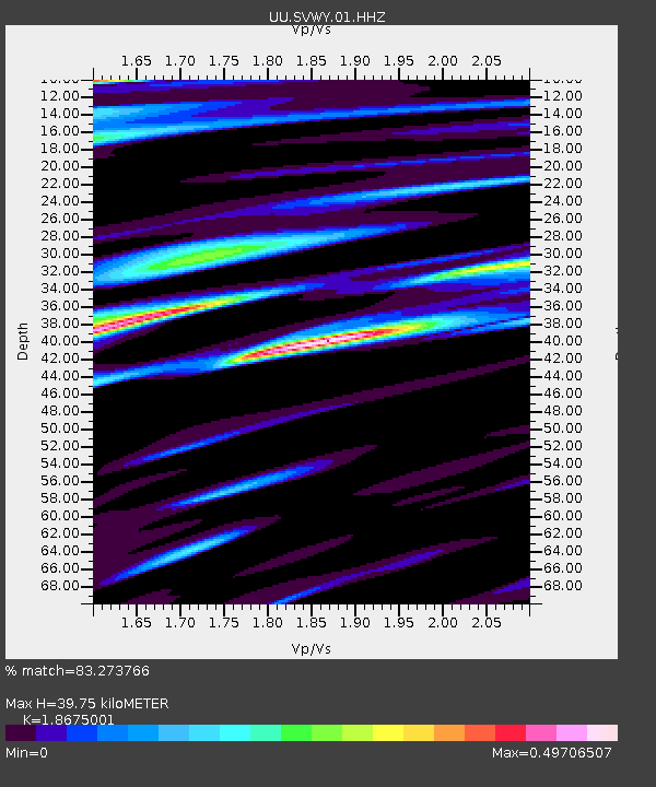
| Estimated Moho Depth: |
39.75 km |
| Estimated Crust Vp/Vs: |
1.87 |
| Assumed Crust Vp: |
6.207 km/s |
| Estimated Crust Vs: |
3.324 km/s |
| Estimated Crust Poisson's Ratio: |
0.30 |
|
| Radial Match: |
83.273766 % |
| Radial Bump: |
400 |
| Transverse Match: |
82.42596 % |
| Transverse Bump: |
400 |
| SOD ConfigId: |
23341671 |
| Insert Time: |
2021-01-12 12:46:05.257 +0000 |
| GWidth: |
2.5 |
| Max Bumps: |
400 |
| Tol: |
0.001 |
|

Signal To Noise
| Channel | StoN | STA | LTA |
| UU:SVWY:01:HHZ:20201229T11:31:38.469985Z | 2.6291893 | 2.4680253E-8 | 9.38702E-9 |
| UU:SVWY:01:HHN:20201229T11:31:38.469985Z | 0.7872536 | 4.5820405E-9 | 5.820285E-9 |
| UU:SVWY:01:HHE:20201229T11:31:38.469985Z | 0.6385077 | 3.7920973E-9 | 5.939E-9 |
| Arrivals |
| Ps | 5.7 SECOND |
| PpPs | 18 SECOND |
| PsPs/PpSs | 24 SECOND |


