You are here: Home > Network List > GE - GEOFON Stations List
> Station CSS GEOFON/GII Station Mathiatis, Cyprus > Earthquake Result Viewer
CSS GEOFON/GII Station Mathiatis, Cyprus - Earthquake Result Viewer
| Earthquake location: |
Northwest Of Kuril Islands |
| Earthquake latitude/longitude: |
47.8/146.2 |
| Earthquake time(UTC): |
2002/11/17 (321) 04:53:53 GMT |
| Earthquake Depth: |
459 km |
| Earthquake Magnitude: |
7.3 MW, 7.3 MW |
| Earthquake Catalog/Contributor: |
WHDF/NEIC |
|
| Network: |
GE GEOFON |
| Station: |
CSS GEOFON/GII Station Mathiatis, Cyprus |
| Lat/Lon: |
34.96 N/33.33 E |
| Elevation: |
396 m |
|
| Distance: |
78.1 deg |
| Az: |
309.343 deg |
| Baz: |
39.384 deg |
| Ray Param: |
0.048527002 |
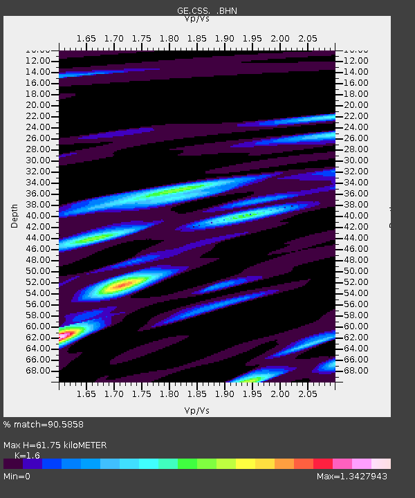
| Estimated Moho Depth: |
61.75 km |
| Estimated Crust Vp/Vs: |
1.60 |
| Assumed Crust Vp: |
5.782 km/s |
| Estimated Crust Vs: |
3.614 km/s |
| Estimated Crust Poisson's Ratio: |
0.18 |
|
| Radial Match: |
90.5858 % |
| Radial Bump: |
319 |
| Transverse Match: |
85.29514 % |
| Transverse Bump: |
400 |
| SOD ConfigId: |
4714 |
| Insert Time: |
2010-03-09 04:28:41.004 +0000 |
| GWidth: |
2.5 |
| Max Bumps: |
400 |
| Tol: |
0.001 |
|

Signal To Noise
| Channel | StoN | STA | LTA |
| GE:CSS: :BHN:20021117T05:04:32.852012Z | 138.79697 | 8.3846035E-6 | 6.040913E-8 |
| GE:CSS: :BHE:20021117T05:04:32.852012Z | 99.648 | 6.8680138E-6 | 6.8922745E-8 |
| GE:CSS: :BHZ:20021117T05:04:32.852012Z | 173.82782 | 2.2393217E-5 | 1.2882411E-7 |
| Arrivals |
| Ps | 6.6 SECOND |
| PpPs | 27 SECOND |
| PsPs/PpSs | 34 SECOND |


