You are here: Home > Network List > YX16 - Raton Basin UNM Broadband Network Stations List
> Station UNM5 Southernmost CO Station > Earthquake Result Viewer
UNM5 Southernmost CO Station - Earthquake Result Viewer
| Earthquake location: |
Northwestern Balkan Region |
| Earthquake latitude/longitude: |
45.4/16.3 |
| Earthquake time(UTC): |
2020/12/29 (364) 11:19:54 GMT |
| Earthquake Depth: |
10 km |
| Earthquake Magnitude: |
6.4 mww |
| Earthquake Catalog/Contributor: |
NEIC PDE/us |
|
| Network: |
YX Raton Basin UNM Broadband Network |
| Station: |
UNM5 Southernmost CO Station |
| Lat/Lon: |
37.12 N/104.78 W |
| Elevation: |
2035 m |
|
| Distance: |
82.2 deg |
| Az: |
316.294 deg |
| Baz: |
37.511 deg |
| Ray Param: |
0.047063403 |
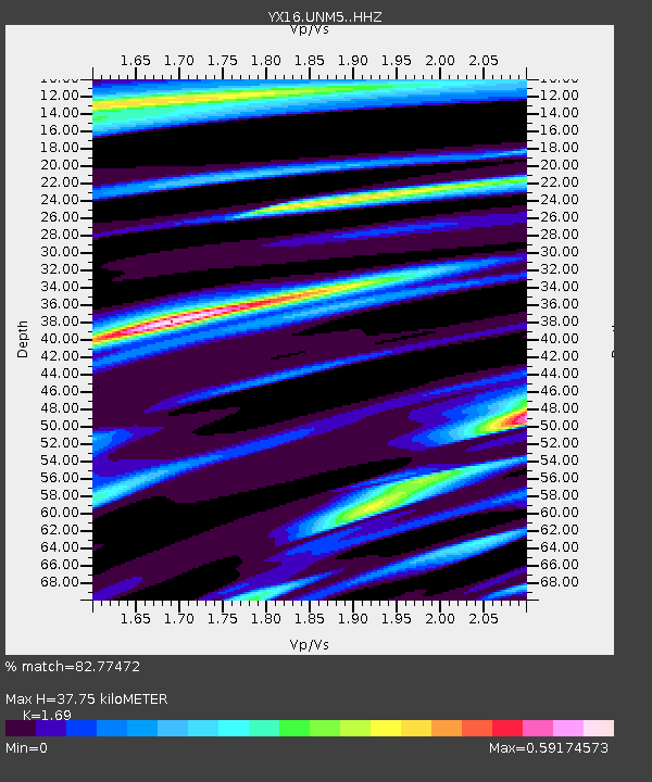
| Estimated Moho Depth: |
37.75 km |
| Estimated Crust Vp/Vs: |
1.69 |
| Assumed Crust Vp: |
6.316 km/s |
| Estimated Crust Vs: |
3.737 km/s |
| Estimated Crust Poisson's Ratio: |
0.23 |
|
| Radial Match: |
82.77472 % |
| Radial Bump: |
400 |
| Transverse Match: |
65.20701 % |
| Transverse Bump: |
378 |
| SOD ConfigId: |
23341671 |
| Insert Time: |
2021-01-12 12:48:17.521 +0000 |
| GWidth: |
2.5 |
| Max Bumps: |
400 |
| Tol: |
0.001 |
|

Signal To Noise
| Channel | StoN | STA | LTA |
| YX:UNM5: :HHZ:20201229T11:31:44.490005Z | 2.1689043 | 5.0357187E-7 | 2.32178E-7 |
| YX:UNM5: :HHN:20201229T11:31:44.490005Z | 1.0144535 | 1.9297303E-7 | 1.9022363E-7 |
| YX:UNM5: :HHE:20201229T11:31:44.490005Z | 1.0014303 | 1.5755182E-7 | 1.573268E-7 |
| Arrivals |
| Ps | 4.2 SECOND |
| PpPs | 16 SECOND |
| PsPs/PpSs | 20 SECOND |


