You are here: Home > Network List > GE - GEOFON Stations List
> Station CSS GEOFON/GII Station Mathiatis, Cyprus > Earthquake Result Viewer
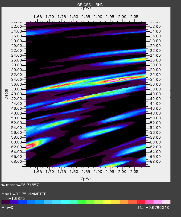
CSS GEOFON/GII Station Mathiatis, Cyprus - Earthquake Result Viewer
| Earthquake location: |
Kuril Islands |
| Earthquake latitude/longitude: |
44.3/150.0 |
| Earthquake time(UTC): |
2002/10/19 (292) 12:09:05 GMT |
| Earthquake Depth: |
33 km |
| Earthquake Magnitude: |
5.4 MB, 6.2 MS, 6.4 MW, 6.1 MW |
| Earthquake Catalog/Contributor: |
WHDF/NEIC |
|
| Network: |
GE GEOFON |
| Station: |
CSS GEOFON/GII Station Mathiatis, Cyprus |
| Lat/Lon: |
34.96 N/33.33 E |
| Elevation: |
396 m |
|
| Distance: |
82.4 deg |
| Az: |
312.203 deg |
| Baz: |
40.363 deg |
| Ray Param: |
0.0468859 |
| Estimated Moho Depth: |
33.75 km |
| Estimated Crust Vp/Vs: |
1.99 |
| Assumed Crust Vp: |
5.782 km/s |
| Estimated Crust Vs: |
2.909 km/s |
| Estimated Crust Poisson's Ratio: |
0.33 |
|
| Radial Match: |
96.71557 % |
| Radial Bump: |
400 |
| Transverse Match: |
95.5147 % |
| Transverse Bump: |
400 |
| SOD ConfigId: |
4714 |
| Insert Time: |
2010-03-09 04:28:47.272 +0000 |
| GWidth: |
2.5 |
| Max Bumps: |
400 |
| Tol: |
0.001 |
|

Signal To Noise
| Channel | StoN | STA | LTA |
| GE:CSS: :BHN:20021019T12:20:52.861018Z | 4.0104175 | 2.3550363E-7 | 5.8722975E-8 |
| GE:CSS: :BHE:20021019T12:20:52.861018Z | 3.157673 | 1.4030765E-7 | 4.443388E-8 |
| GE:CSS: :BHZ:20021019T12:20:52.861018Z | 8.462182 | 4.8763644E-7 | 5.7625382E-8 |
| Arrivals |
| Ps | 5.9 SECOND |
| PpPs | 17 SECOND |
| PsPs/PpSs | 23 SECOND |


