You are here: Home > Network List > GE - GEOFON Stations List
> Station CSS GEOFON/GII Station Mathiatis, Cyprus > Earthquake Result Viewer
CSS GEOFON/GII Station Mathiatis, Cyprus - Earthquake Result Viewer
| Earthquake location: |
Jan Mayen Island Region |
| Earthquake latitude/longitude: |
71.1/-7.7 |
| Earthquake time(UTC): |
2004/04/14 (105) 23:07:39 GMT |
| Earthquake Depth: |
12 km |
| Earthquake Magnitude: |
5.8 MB, 5.6 MS, 6.0 MW, 6.0 MW |
| Earthquake Catalog/Contributor: |
WHDF/NEIC |
|
| Network: |
GE GEOFON |
| Station: |
CSS GEOFON/GII Station Mathiatis, Cyprus |
| Lat/Lon: |
34.96 N/33.33 E |
| Elevation: |
396 m |
|
| Distance: |
42.2 deg |
| Az: |
126.478 deg |
| Baz: |
341.364 deg |
| Ray Param: |
0.073329866 |
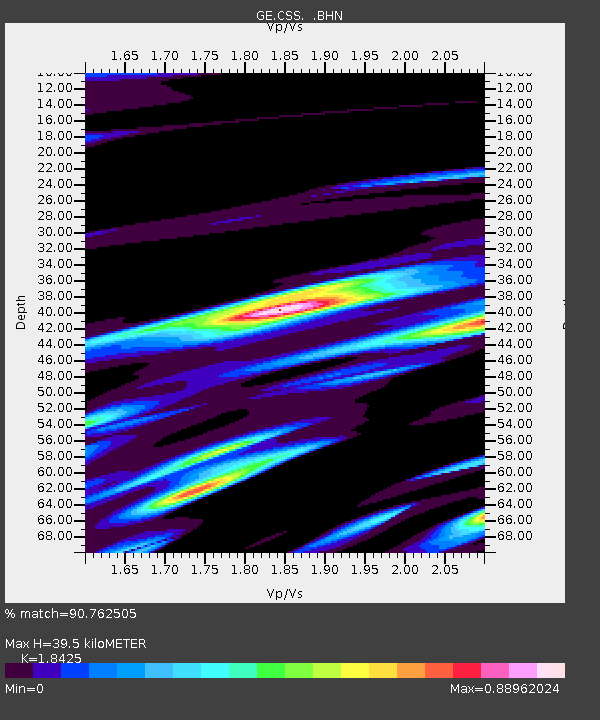
| Estimated Moho Depth: |
39.5 km |
| Estimated Crust Vp/Vs: |
1.84 |
| Assumed Crust Vp: |
5.782 km/s |
| Estimated Crust Vs: |
3.138 km/s |
| Estimated Crust Poisson's Ratio: |
0.29 |
|
| Radial Match: |
90.762505 % |
| Radial Bump: |
400 |
| Transverse Match: |
82.84982 % |
| Transverse Bump: |
400 |
| SOD ConfigId: |
2459 |
| Insert Time: |
2010-03-09 04:29:36.806 +0000 |
| GWidth: |
2.5 |
| Max Bumps: |
400 |
| Tol: |
0.001 |
|

Signal To Noise
| Channel | StoN | STA | LTA |
| GE:CSS: :BHN:20040414T23:15:01.341001Z | 10.207541 | 7.5328876E-7 | 7.3797274E-8 |
| GE:CSS: :BHE:20040414T23:15:01.341001Z | 5.8102803 | 4.040182E-7 | 6.953506E-8 |
| GE:CSS: :BHZ:20040414T23:15:01.341001Z | 16.60355 | 1.1940709E-6 | 7.19166E-8 |
| Arrivals |
| Ps | 6.1 SECOND |
| PpPs | 18 SECOND |
| PsPs/PpSs | 24 SECOND |


