You are here: Home > Network List > PF - Volcanologic Network of Piton de Fournaise-OVPF Stations List
> Station HIM cratere Himiltrude > Earthquake Result Viewer
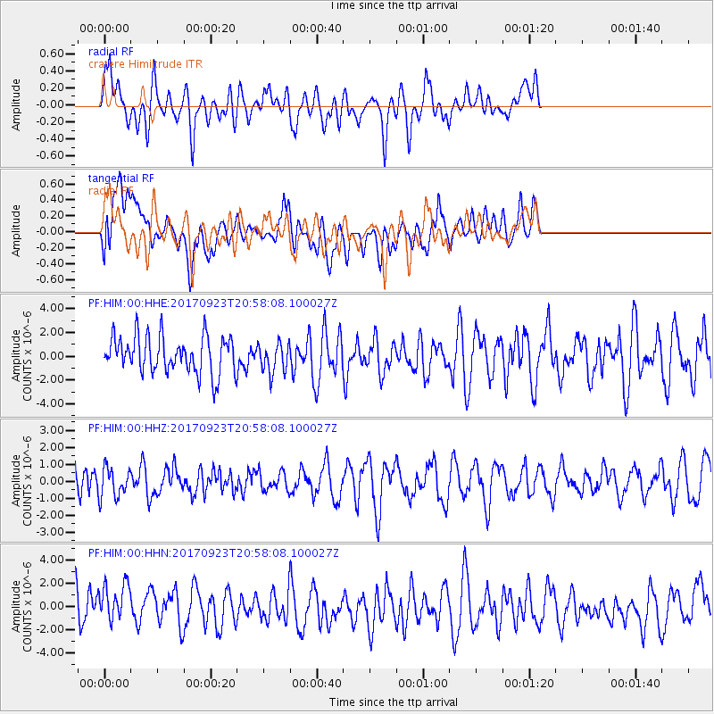
HIM cratere Himiltrude - Earthquake Result Viewer
*The percent match for this event was below the threshold and hence no stack was calculated.
| Earthquake location: |
Mindanao, Philippines |
| Earthquake latitude/longitude: |
7.6/124.9 |
| Earthquake time(UTC): |
2017/09/23 (266) 20:47:08 GMT |
| Earthquake Depth: |
31 km |
| Earthquake Magnitude: |
5.7 Mww |
| Earthquake Catalog/Contributor: |
NEIC PDE/us |
|
| Network: |
PF Volcanologic Network of Piton de Fournaise-OVPF |
| Station: |
HIM cratere Himiltrude |
| Lat/Lon: |
21.21 S/55.72 E |
| Elevation: |
1958 m |
|
| Distance: |
73.6 deg |
| Az: |
245.339 deg |
| Baz: |
74.901 deg |
| Ray Param: |
$rayparam |
*The percent match for this event was below the threshold and hence was not used in the summary stack. |
|
| Radial Match: |
53.170242 % |
| Radial Bump: |
400 |
| Transverse Match: |
49.901573 % |
| Transverse Bump: |
400 |
| SOD ConfigId: |
2364251 |
| Insert Time: |
2017-10-09 20:48:04.031 +0000 |
| GWidth: |
2.5 |
| Max Bumps: |
400 |
| Tol: |
0.001 |
|
Signal To Noise
| Channel | StoN | STA | LTA |
| PF:HIM:00:HHZ:20170923T20:58:08.100027Z | 1.0169375 | 8.687757E-7 | 8.5430594E-7 |
| PF:HIM:00:HHN:20170923T20:58:08.100027Z | 1.0583614 | 1.9802087E-6 | 1.8710135E-6 |
| PF:HIM:00:HHE:20170923T20:58:08.100027Z | 0.84304637 | 1.2937465E-6 | 1.534609E-6 |
| Arrivals |
| Ps | |
| PpPs | |
| PsPs/PpSs | |


