You are here: Home > Network List > CI - Caltech Regional Seismic Network Stations List
> Station DAN Danby, California, USA > Earthquake Result Viewer
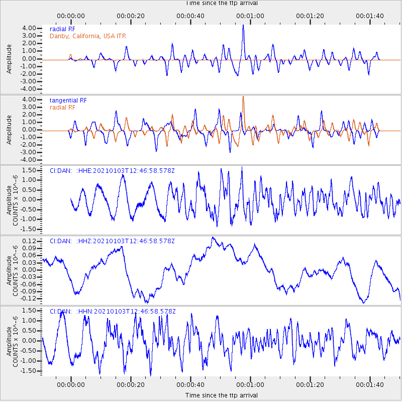
DAN Danby, California, USA - Earthquake Result Viewer
*The percent match for this event was below the threshold and hence no stack was calculated.
| Earthquake location: |
Andreanof Islands, Aleutian Is. |
| Earthquake latitude/longitude: |
51.2/-179.8 |
| Earthquake time(UTC): |
2021/01/03 (003) 12:38:48 GMT |
| Earthquake Depth: |
17 km |
| Earthquake Magnitude: |
6.1 Mww |
| Earthquake Catalog/Contributor: |
NEIC PDE/us |
|
| Network: |
CI Caltech Regional Seismic Network |
| Station: |
DAN Danby, California, USA |
| Lat/Lon: |
34.64 N/115.38 W |
| Elevation: |
398 m |
|
| Distance: |
48.4 deg |
| Az: |
83.877 deg |
| Baz: |
310.63 deg |
| Ray Param: |
$rayparam |
*The percent match for this event was below the threshold and hence was not used in the summary stack. |
|
| Radial Match: |
54.583042 % |
| Radial Bump: |
400 |
| Transverse Match: |
41.778126 % |
| Transverse Bump: |
400 |
| SOD ConfigId: |
23341671 |
| Insert Time: |
2021-01-17 13:42:40.754 +0000 |
| GWidth: |
2.5 |
| Max Bumps: |
400 |
| Tol: |
0.001 |
|
Signal To Noise
| Channel | StoN | STA | LTA |
| CI:DAN: :HHZ:20210103T12:46:58.578Z | 0.29962832 | 5.99136E-8 | 1.9995974E-7 |
| CI:DAN: :HHN:20210103T12:46:58.578Z | 1.1099355 | 8.06913E-7 | 7.269909E-7 |
| CI:DAN: :HHE:20210103T12:46:58.578Z | 1.1634417 | 6.676706E-7 | 5.738754E-7 |
| Arrivals |
| Ps | |
| PpPs | |
| PsPs/PpSs | |


