You are here: Home > Network List > US - United States National Seismic Network Stations List
> Station DGMT Dagmar, Montana, USA > Earthquake Result Viewer
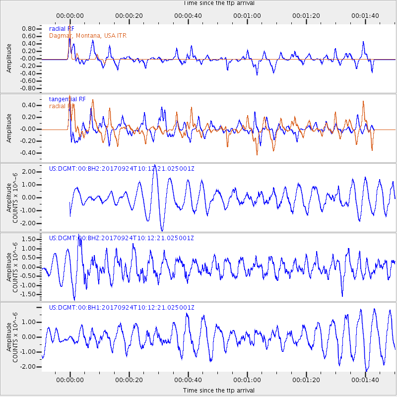
DGMT Dagmar, Montana, USA - Earthquake Result Viewer
*The percent match for this event was below the threshold and hence no stack was calculated.
| Earthquake location: |
Near Coast Of Oaxaca, Mexico |
| Earthquake latitude/longitude: |
15.3/-94.1 |
| Earthquake time(UTC): |
2017/09/24 (267) 10:06:12 GMT |
| Earthquake Depth: |
55 km |
| Earthquake Magnitude: |
5.8 Mww |
| Earthquake Catalog/Contributor: |
NEIC PDE/us |
|
| Network: |
US United States National Seismic Network |
| Station: |
DGMT Dagmar, Montana, USA |
| Lat/Lon: |
48.47 N/104.20 W |
| Elevation: |
0.0 m |
|
| Distance: |
34.1 deg |
| Az: |
347.982 deg |
| Baz: |
162.43 deg |
| Ray Param: |
$rayparam |
*The percent match for this event was below the threshold and hence was not used in the summary stack. |
|
| Radial Match: |
76.985176 % |
| Radial Bump: |
392 |
| Transverse Match: |
42.458996 % |
| Transverse Bump: |
350 |
| SOD ConfigId: |
2364251 |
| Insert Time: |
2017-10-09 20:50:23.797 +0000 |
| GWidth: |
2.5 |
| Max Bumps: |
400 |
| Tol: |
0.001 |
|
Signal To Noise
| Channel | StoN | STA | LTA |
| US:DGMT:00:BHZ:20170924T10:12:21.025001Z | 4.4172153 | 1.0561707E-6 | 2.391033E-7 |
| US:DGMT:00:BH1:20170924T10:12:21.025001Z | 0.6733222 | 3.671152E-7 | 5.452296E-7 |
| US:DGMT:00:BH2:20170924T10:12:21.025001Z | 3.3194966 | 1.5584174E-6 | 4.6947397E-7 |
| Arrivals |
| Ps | |
| PpPs | |
| PsPs/PpSs | |


