You are here: Home > Network List > US - United States National Seismic Network Stations List
> Station EGMT Eagleton, Montana, USA > Earthquake Result Viewer
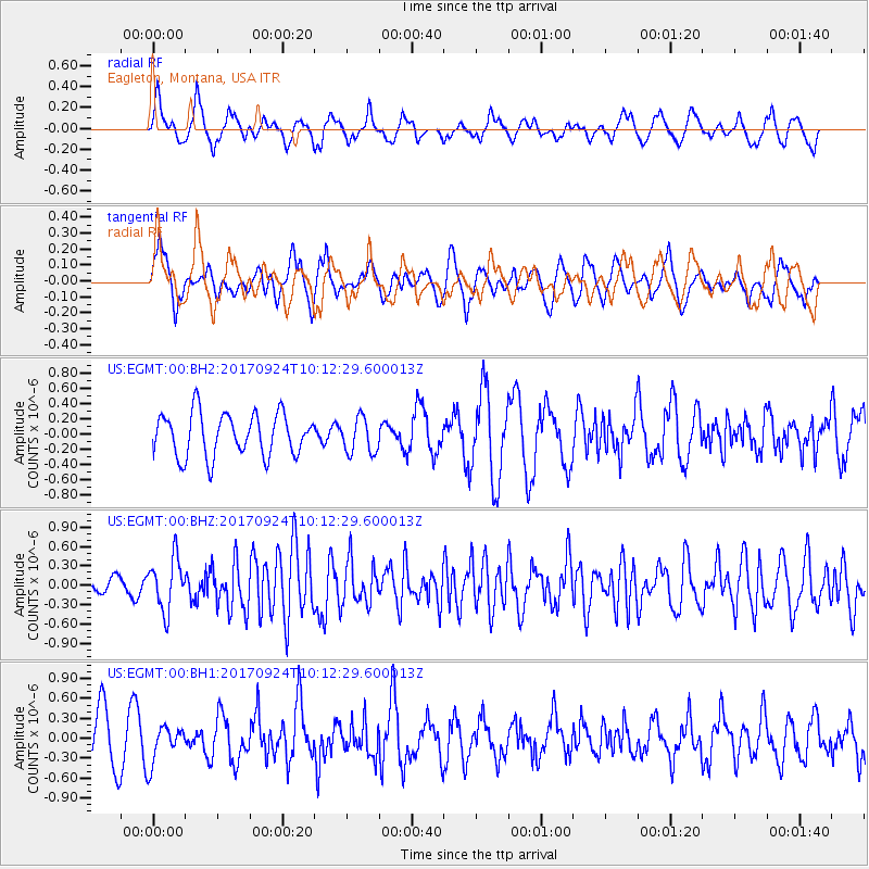
EGMT Eagleton, Montana, USA - Earthquake Result Viewer
*The percent match for this event was below the threshold and hence no stack was calculated.
| Earthquake location: |
Near Coast Of Oaxaca, Mexico |
| Earthquake latitude/longitude: |
15.3/-94.1 |
| Earthquake time(UTC): |
2017/09/24 (267) 10:06:12 GMT |
| Earthquake Depth: |
55 km |
| Earthquake Magnitude: |
5.8 Mww |
| Earthquake Catalog/Contributor: |
NEIC PDE/us |
|
| Network: |
US United States National Seismic Network |
| Station: |
EGMT Eagleton, Montana, USA |
| Lat/Lon: |
48.02 N/109.75 W |
| Elevation: |
1055 m |
|
| Distance: |
35.1 deg |
| Az: |
341.623 deg |
| Baz: |
153.055 deg |
| Ray Param: |
$rayparam |
*The percent match for this event was below the threshold and hence was not used in the summary stack. |
|
| Radial Match: |
65.588524 % |
| Radial Bump: |
400 |
| Transverse Match: |
52.13422 % |
| Transverse Bump: |
400 |
| SOD ConfigId: |
2364251 |
| Insert Time: |
2017-10-09 20:50:24.977 +0000 |
| GWidth: |
2.5 |
| Max Bumps: |
400 |
| Tol: |
0.001 |
|
Signal To Noise
| Channel | StoN | STA | LTA |
| US:EGMT:00:BHZ:20170924T10:12:29.600013Z | 2.9663699 | 3.9865367E-7 | 1.3439109E-7 |
| US:EGMT:00:BH1:20170924T10:12:29.600013Z | 0.70662594 | 2.8067578E-7 | 3.972056E-7 |
| US:EGMT:00:BH2:20170924T10:12:29.600013Z | 0.8294367 | 2.3254816E-7 | 2.8036877E-7 |
| Arrivals |
| Ps | |
| PpPs | |
| PsPs/PpSs | |


