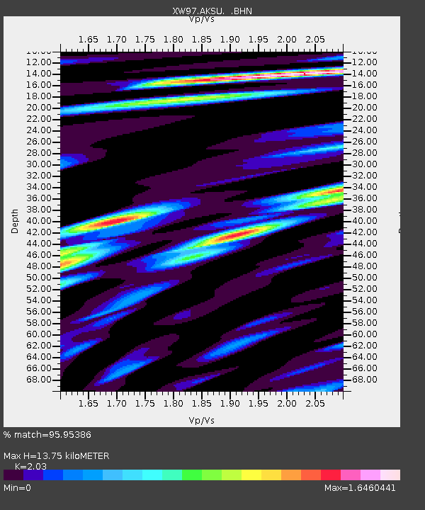
AKSU XW.AKSU - Earthquake Result Viewer
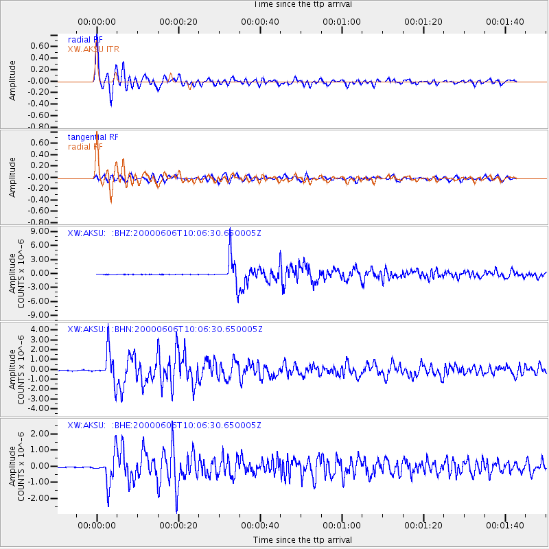
Earthquake location: Southern Sumatra, Indonesia
Earthquake latitude/longitude: -5.1/102.7
Earthquake time(UTC): 2000/06/06 (158) 09:58:06 GMT
Earthquake Depth: 33 km
Earthquake Magnitude: 5.8 MB, 6.1 MS, 6.2 MW, 6.1 MW
Earthquake Catalog/Contributor: WHDF/NEIC
Network: XW Tien Shan Continental Dynamics
Station: AKSU XW.AKSU
Lat/Lon: 41.14 N/80.11 E
Elevation: 1109 m
Distance: 50.4 deg
Az: 337.898 deg
Baz: 150.248 deg
Ray Param: 0.06798575
Estimated Moho Depth: 13.75 km
Estimated Crust Vp/Vs: 2.03
Assumed Crust Vp: 6.129 km/s
Estimated Crust Vs: 3.019 km/s
Estimated Crust Poisson's Ratio: 0.34
Radial Match: 95.95386 %
Radial Bump: 400
Transverse Match: 84.35824 %
Transverse Bump: 400
SOD ConfigId: 20082
Insert Time: 2010-02-26 15:14:14.200 +0000
GWidth: 2.5
Max Bumps: 400
Tol: 0.001

Signal To Noise

ChannelStoNSTALTA
XW:AKSU: :BHN:20000606T10:06:30.650005Z55.355351.6238636E-62.9335258E-8
XW:AKSU: :BHE:20000606T10:06:30.650005Z22.6373339.315098E-74.1149274E-8
XW:AKSU: :BHZ:20000606T10:06:30.650005Z120.7369463.1791499E-62.633121E-8
Arrivals
Ps2.4 SECOND
PpPs6.5 SECOND
PsPs/PpSs8.9 SECOND