You are here: Home > Network List > US - United States National Seismic Network Stations List
> Station BOZ Bozeman, Montana, USA > Earthquake Result Viewer
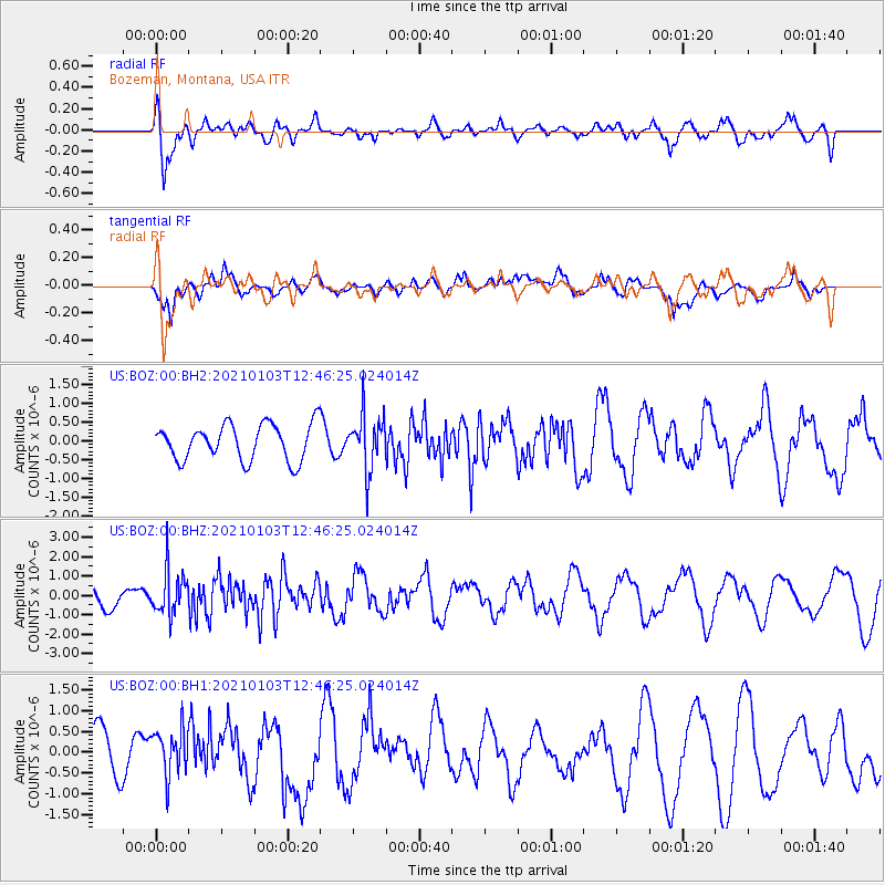
BOZ Bozeman, Montana, USA - Earthquake Result Viewer
*The percent match for this event was below the threshold and hence no stack was calculated.
| Earthquake location: |
Andreanof Islands, Aleutian Is. |
| Earthquake latitude/longitude: |
51.2/-179.8 |
| Earthquake time(UTC): |
2021/01/03 (003) 12:38:48 GMT |
| Earthquake Depth: |
17 km |
| Earthquake Magnitude: |
6.1 Mww |
| Earthquake Catalog/Contributor: |
NEIC PDE/us |
|
| Network: |
US United States National Seismic Network |
| Station: |
BOZ Bozeman, Montana, USA |
| Lat/Lon: |
45.65 N/111.63 W |
| Elevation: |
1589 m |
|
| Distance: |
44.1 deg |
| Az: |
69.296 deg |
| Baz: |
302.939 deg |
| Ray Param: |
$rayparam |
*The percent match for this event was below the threshold and hence was not used in the summary stack. |
|
| Radial Match: |
63.33276 % |
| Radial Bump: |
400 |
| Transverse Match: |
45.995796 % |
| Transverse Bump: |
400 |
| SOD ConfigId: |
23341671 |
| Insert Time: |
2021-01-17 13:59:52.033 +0000 |
| GWidth: |
2.5 |
| Max Bumps: |
400 |
| Tol: |
0.001 |
|
Signal To Noise
| Channel | StoN | STA | LTA |
| US:BOZ:00:BHZ:20210103T12:46:25.024014Z | 2.613165 | 1.1336623E-6 | 4.338273E-7 |
| US:BOZ:00:BH1:20210103T12:46:25.024014Z | 0.96040076 | 6.0073273E-7 | 6.2550214E-7 |
| US:BOZ:00:BH2:20210103T12:46:25.024014Z | 1.5414641 | 7.2721446E-7 | 4.7176863E-7 |
| Arrivals |
| Ps | |
| PpPs | |
| PsPs/PpSs | |


