You are here: Home > Network List > UW - Pacific Northwest Regional Seismic Network Stations List
> Station HOOD Mt Hood Meadows, OR CREST BB SMO > Earthquake Result Viewer
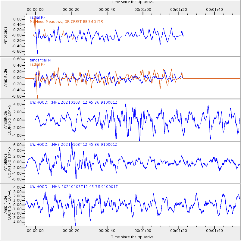
HOOD Mt Hood Meadows, OR CREST BB SMO - Earthquake Result Viewer
*The percent match for this event was below the threshold and hence no stack was calculated.
| Earthquake location: |
Andreanof Islands, Aleutian Is. |
| Earthquake latitude/longitude: |
51.2/-179.8 |
| Earthquake time(UTC): |
2021/01/03 (003) 12:38:48 GMT |
| Earthquake Depth: |
17 km |
| Earthquake Magnitude: |
6.1 Mww |
| Earthquake Catalog/Contributor: |
NEIC PDE/us |
|
| Network: |
UW Pacific Northwest Regional Seismic Network |
| Station: |
HOOD Mt Hood Meadows, OR CREST BB SMO |
| Lat/Lon: |
45.32 N/121.65 W |
| Elevation: |
1520 m |
|
| Distance: |
38.3 deg |
| Az: |
75.325 deg |
| Baz: |
300.349 deg |
| Ray Param: |
$rayparam |
*The percent match for this event was below the threshold and hence was not used in the summary stack. |
|
| Radial Match: |
73.06544 % |
| Radial Bump: |
400 |
| Transverse Match: |
60.951885 % |
| Transverse Bump: |
400 |
| SOD ConfigId: |
23341671 |
| Insert Time: |
2021-01-17 14:01:07.480 +0000 |
| GWidth: |
2.5 |
| Max Bumps: |
400 |
| Tol: |
0.001 |
|
Signal To Noise
| Channel | StoN | STA | LTA |
| UW:HOOD: :HHZ:20210103T12:45:36.910001Z | 1.6821116 | 1.6240422E-6 | 9.654783E-7 |
| UW:HOOD: :HHN:20210103T12:45:36.910001Z | 0.73578244 | 9.19676E-7 | 1.2499293E-6 |
| UW:HOOD: :HHE:20210103T12:45:36.910001Z | 0.48422515 | 6.516392E-7 | 1.345736E-6 |
| Arrivals |
| Ps | |
| PpPs | |
| PsPs/PpSs | |


