You are here: Home > Network List > WY - Yellowstone Wyoming Seismic Network Stations List
> Station YHH Holmes Hill, YNP, WY, USA > Earthquake Result Viewer
YHH Holmes Hill, YNP, WY, USA - Earthquake Result Viewer
*The percent match for this event was below the threshold and hence no stack was calculated.
| Earthquake location: |
Andreanof Islands, Aleutian Is. |
| Earthquake latitude/longitude: |
51.2/-179.8 |
| Earthquake time(UTC): |
2021/01/03 (003) 12:38:48 GMT |
| Earthquake Depth: |
17 km |
| Earthquake Magnitude: |
6.1 Mww |
| Earthquake Catalog/Contributor: |
NEIC PDE/us |
|
| Network: |
WY Yellowstone Wyoming Seismic Network |
| Station: |
YHH Holmes Hill, YNP, WY, USA |
| Lat/Lon: |
44.79 N/110.85 W |
| Elevation: |
2717 m |
|
| Distance: |
45.1 deg |
| Az: |
69.884 deg |
| Baz: |
303.909 deg |
| Ray Param: |
$rayparam |
*The percent match for this event was below the threshold and hence was not used in the summary stack. |
|
| Radial Match: |
77.63213 % |
| Radial Bump: |
394 |
| Transverse Match: |
72.28399 % |
| Transverse Bump: |
400 |
| SOD ConfigId: |
23341671 |
| Insert Time: |
2021-01-17 14:02:02.443 +0000 |
| GWidth: |
2.5 |
| Max Bumps: |
400 |
| Tol: |
0.001 |
|
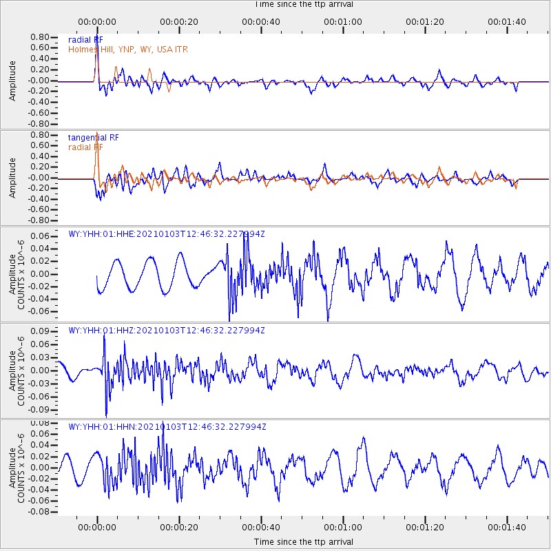
Signal To Noise
| Channel | StoN | STA | LTA |
| WY:YHH:01:HHZ:20210103T12:46:32.227994Z | 2.2626185 | 3.6198536E-8 | 1.5998515E-8 |
| WY:YHH:01:HHN:20210103T12:46:32.227994Z | 2.2292225 | 2.6831435E-8 | 1.203623E-8 |
| WY:YHH:01:HHE:20210103T12:46:32.227994Z | 1.4739598 | 3.0396286E-8 | 2.0622196E-8 |
| Arrivals |
| Ps | |
| PpPs | |
| PsPs/PpSs | |


