You are here: Home > Network List > GE - GEOFON Stations List
> Station JER GII/GEOFON Station Jerusalem, Israel > Earthquake Result Viewer
JER GII/GEOFON Station Jerusalem, Israel - Earthquake Result Viewer
| Earthquake location: |
Samar, Philippines |
| Earthquake latitude/longitude: |
12.8/125.1 |
| Earthquake time(UTC): |
1996/06/14 (166) 15:04:40 GMT |
| Earthquake Depth: |
29 km |
| Earthquake Magnitude: |
5.6 MB, 5.8 MS, 6.1 UNKNOWN, 5.9 MW |
| Earthquake Catalog/Contributor: |
WHDF/NEIC |
|
| Network: |
GE GEOFON |
| Station: |
JER GII/GEOFON Station Jerusalem, Israel |
| Lat/Lon: |
31.77 N/35.20 E |
| Elevation: |
770 m |
|
| Distance: |
83.3 deg |
| Az: |
300.944 deg |
| Baz: |
79.182 deg |
| Ray Param: |
0.046284907 |
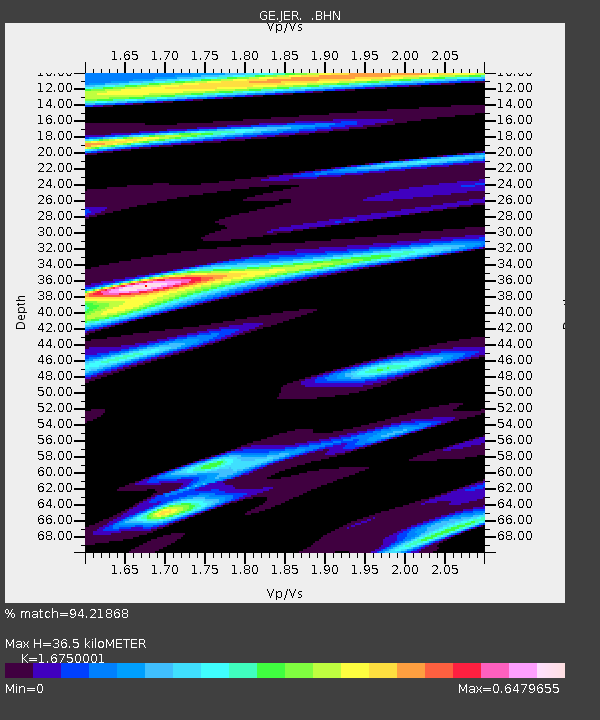
| Estimated Moho Depth: |
36.5 km |
| Estimated Crust Vp/Vs: |
1.68 |
| Assumed Crust Vp: |
6.391 km/s |
| Estimated Crust Vs: |
3.815 km/s |
| Estimated Crust Poisson's Ratio: |
0.22 |
|
| Radial Match: |
94.21868 % |
| Radial Bump: |
355 |
| Transverse Match: |
80.63337 % |
| Transverse Bump: |
400 |
| SOD ConfigId: |
6273 |
| Insert Time: |
2010-03-09 04:31:22.633 +0000 |
| GWidth: |
2.5 |
| Max Bumps: |
400 |
| Tol: |
0.001 |
|

Signal To Noise
| Channel | StoN | STA | LTA |
| GE:JER: :BHN:19960614T15:16:33.166003Z | 0.9145481 | 9.228056E-8 | 1.009029E-7 |
| GE:JER: :BHE:19960614T15:16:33.166003Z | 1.3588144 | 1.6587123E-7 | 1.2207056E-7 |
| GE:JER: :BHZ:19960614T15:16:33.166003Z | 3.0236878 | 4.3202704E-7 | 1.4288084E-7 |
| Arrivals |
| Ps | 4.0 SECOND |
| PpPs | 15 SECOND |
| PsPs/PpSs | 19 SECOND |


