You are here: Home > Network List > GS - US Geological Survey Networks Stations List
> Station MT02 Nevada Ogden Rd, Helena Natl Forest, Montana, USA > Earthquake Result Viewer
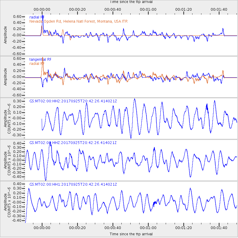
MT02 Nevada Ogden Rd, Helena Natl Forest, Montana, USA - Earthquake Result Viewer
*The percent match for this event was below the threshold and hence no stack was calculated.
| Earthquake location: |
New Britain Region, P.N.G. |
| Earthquake latitude/longitude: |
-6.2/152.7 |
| Earthquake time(UTC): |
2017/09/25 (268) 20:29:23 GMT |
| Earthquake Depth: |
6.0 km |
| Earthquake Magnitude: |
5.9 Mww |
| Earthquake Catalog/Contributor: |
NEIC PDE/us |
|
| Network: |
GS US Geological Survey Networks |
| Station: |
MT02 Nevada Ogden Rd, Helena Natl Forest, Montana, USA |
| Lat/Lon: |
46.86 N/112.88 W |
| Elevation: |
1672 m |
|
| Distance: |
97.5 deg |
| Az: |
43.64 deg |
| Baz: |
268.948 deg |
| Ray Param: |
$rayparam |
*The percent match for this event was below the threshold and hence was not used in the summary stack. |
|
| Radial Match: |
56.75874 % |
| Radial Bump: |
400 |
| Transverse Match: |
41.601337 % |
| Transverse Bump: |
400 |
| SOD ConfigId: |
2364251 |
| Insert Time: |
2017-10-09 20:52:26.172 +0000 |
| GWidth: |
2.5 |
| Max Bumps: |
400 |
| Tol: |
0.001 |
|
Signal To Noise
| Channel | StoN | STA | LTA |
| GS:MT02:00:HHZ:20170925T20:42:26.414021Z | 2.1024091 | 2.8019593E-7 | 1.3327374E-7 |
| GS:MT02:00:HH1:20170925T20:42:26.414021Z | 0.5332376 | 8.5138694E-8 | 1.596637E-7 |
| GS:MT02:00:HH2:20170925T20:42:26.414021Z | 0.7536843 | 9.650518E-8 | 1.2804458E-7 |
| Arrivals |
| Ps | |
| PpPs | |
| PsPs/PpSs | |


