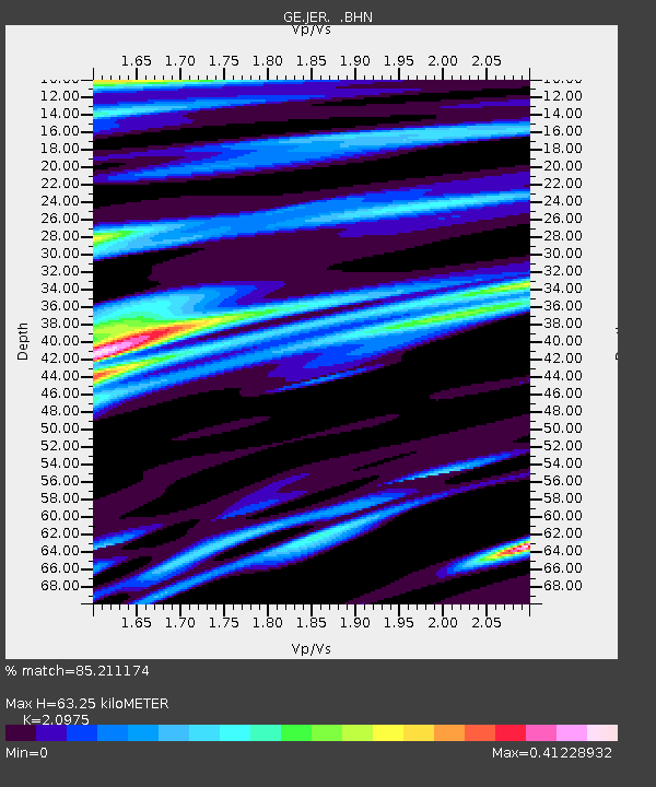
JER GII/GEOFON Station Jerusalem, Israel - Earthquake Result Viewer

Earthquake location: Bonin Islands, Japan Region
Earthquake latitude/longitude: 27.7/139.7
Earthquake time(UTC): 1996/06/26 (178) 03:22:03 GMT
Earthquake Depth: 469 km
Earthquake Magnitude: 5.5 MB, 6.3 UNKNOWN, 5.4 MB
Earthquake Catalog/Contributor: WHDF/NEIC
Network: GE GEOFON
Station: JER GII/GEOFON Station Jerusalem, Israel
Lat/Lon: 31.77 N/35.20 E
Elevation: 770 m
Distance: 87.0 deg
Az: 304.354 deg
Baz: 59.23 deg
Ray Param: 0.042392038
Estimated Moho Depth: 63.25 km
Estimated Crust Vp/Vs: 2.10
Assumed Crust Vp: 6.391 km/s
Estimated Crust Vs: 3.047 km/s
Estimated Crust Poisson's Ratio: 0.35
Radial Match: 85.211174 %
Radial Bump: 400
Transverse Match: 75.50505 %
Transverse Bump: 400
SOD ConfigId: 6273
Insert Time: 2010-03-09 04:31:24.874 +0000
GWidth: 2.5
Max Bumps: 400
Tol: 0.001

Signal To Noise

ChannelStoNSTALTA
GE:JER: :BHN:19960626T03:33:26.266016Z1.50585231.5481926E-71.0281172E-7
GE:JER: :BHE:19960626T03:33:26.266016Z2.29567892.8457737E-71.2396218E-7
GE:JER: :BHZ:19960626T03:33:26.266016Z8.0993229.423971E-71.1635506E-7
Arrivals
Ps11 SECOND
PpPs30 SECOND
PsPs/PpSs41 SECOND