You are here: Home > Network List > GE - GEOFON Stations List
> Station JER GII Station Jerusalem, Israel > Earthquake Result Viewer
JER GII Station Jerusalem, Israel - Earthquake Result Viewer
| Earthquake location: |
Java, Indonesia |
| Earthquake latitude/longitude: |
-7.9/107.5 |
| Earthquake time(UTC): |
1996/12/09 (344) 03:54:16 GMT |
| Earthquake Depth: |
51 km |
| Earthquake Magnitude: |
5.5 MB, 5.7 MS, 6.1 UNKNOWN, 5.9 MW |
| Earthquake Catalog/Contributor: |
WHDF/NEIC |
|
| Network: |
GE GEOFON |
| Station: |
JER GII Station Jerusalem, Israel |
| Lat/Lon: |
31.77 N/35.20 E |
| Elevation: |
770 m |
|
| Distance: |
79.4 deg |
| Az: |
304.352 deg |
| Baz: |
106.231 deg |
| Ray Param: |
0.04892637 |
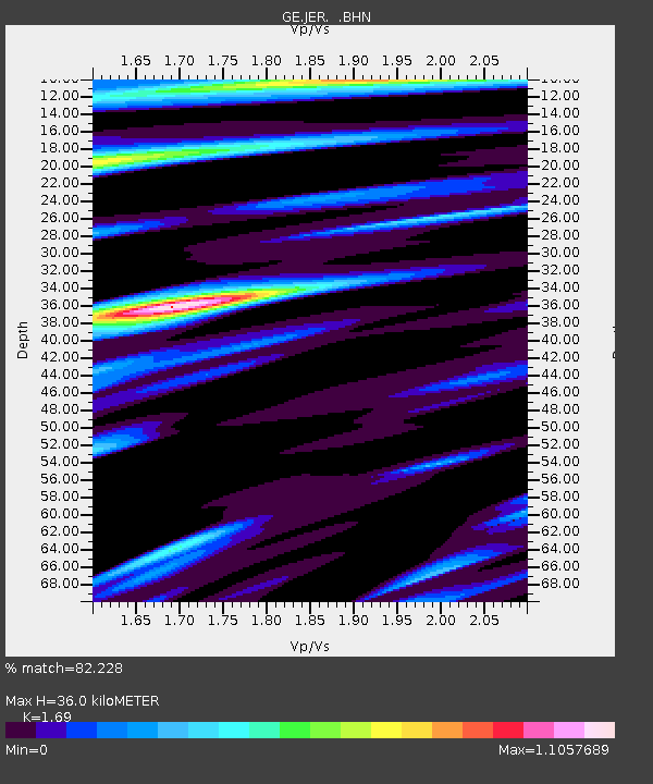
| Estimated Moho Depth: |
36.0 km |
| Estimated Crust Vp/Vs: |
1.69 |
| Assumed Crust Vp: |
6.391 km/s |
| Estimated Crust Vs: |
3.781 km/s |
| Estimated Crust Poisson's Ratio: |
0.23 |
|
| Radial Match: |
82.228 % |
| Radial Bump: |
400 |
| Transverse Match: |
73.89133 % |
| Transverse Bump: |
400 |
| SOD ConfigId: |
6273 |
| Insert Time: |
2010-03-09 04:31:30.938 +0000 |
| GWidth: |
2.5 |
| Max Bumps: |
400 |
| Tol: |
0.001 |
|

Signal To Noise
| Channel | StoN | STA | LTA |
| GE:JER: :BHN:19961209T04:05:45.682996Z | 1.3755703 | 1.519909E-7 | 1.1049301E-7 |
| GE:JER: :BHE:19961209T04:05:45.682996Z | 1.1074221 | 2.8667674E-7 | 2.5886854E-7 |
| GE:JER: :BHZ:19961209T04:05:45.682996Z | 4.7605176 | 6.8358656E-7 | 1.4359502E-7 |
| Arrivals |
| Ps | 4.0 SECOND |
| PpPs | 15 SECOND |
| PsPs/PpSs | 19 SECOND |


