You are here: Home > Network List > GE - GEOFON Stations List
> Station JER GII Station Jerusalem, Israel > Earthquake Result Viewer
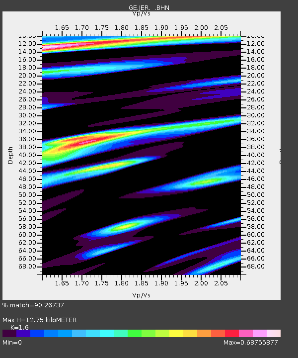
JER GII Station Jerusalem, Israel - Earthquake Result Viewer
| Earthquake location: |
Mindanao, Philippines |
| Earthquake latitude/longitude: |
8.1/126.6 |
| Earthquake time(UTC): |
1997/09/15 (258) 13:05:42 GMT |
| Earthquake Depth: |
51 km |
| Earthquake Magnitude: |
5.8 MB, 5.7 MS, 6.1 UNKNOWN, 6.1 MW |
| Earthquake Catalog/Contributor: |
WHDF/NEIC |
|
| Network: |
GE GEOFON |
| Station: |
JER GII Station Jerusalem, Israel |
| Lat/Lon: |
31.77 N/35.20 E |
| Elevation: |
770 m |
|
| Distance: |
87.0 deg |
| Az: |
301.503 deg |
| Baz: |
82.389 deg |
| Ray Param: |
0.04354311 |
| Estimated Moho Depth: |
12.75 km |
| Estimated Crust Vp/Vs: |
1.60 |
| Assumed Crust Vp: |
6.391 km/s |
| Estimated Crust Vs: |
3.994 km/s |
| Estimated Crust Poisson's Ratio: |
0.18 |
|
| Radial Match: |
90.26737 % |
| Radial Bump: |
400 |
| Transverse Match: |
76.05277 % |
| Transverse Bump: |
400 |
| SOD ConfigId: |
6273 |
| Insert Time: |
2010-03-09 04:31:40.009 +0000 |
| GWidth: |
2.5 |
| Max Bumps: |
400 |
| Tol: |
0.001 |
|

Signal To Noise
| Channel | StoN | STA | LTA |
| GE:JER: :BHN:19970915T13:17:51.392993Z | 1.1865673 | 1.9066826E-7 | 1.6068894E-7 |
| GE:JER: :BHE:19970915T13:17:51.392993Z | 1.4912083 | 2.6611974E-7 | 1.7845913E-7 |
| GE:JER: :BHZ:19970915T13:17:51.392993Z | 3.688267 | 6.6765455E-7 | 1.810212E-7 |
| Arrivals |
| Ps | 1.2 SECOND |
| PpPs | 5.1 SECOND |
| PsPs/PpSs | 6.3 SECOND |


