You are here: Home > Network List > TA - USArray Transportable Network (new EarthScope stations) Stations List
> Station R33M Jennings River, BC, CAN > Earthquake Result Viewer
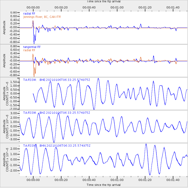
R33M Jennings River, BC, CAN - Earthquake Result Viewer
*The percent match for this event was below the threshold and hence no stack was calculated.
| Earthquake location: |
Kermadec Islands Region |
| Earthquake latitude/longitude: |
-29.1/-176.9 |
| Earthquake time(UTC): |
2021/01/06 (006) 06:20:32 GMT |
| Earthquake Depth: |
26 km |
| Earthquake Magnitude: |
6.2 mww |
| Earthquake Catalog/Contributor: |
NEIC PDE/us |
|
| Network: |
TA USArray Transportable Network (new EarthScope stations) |
| Station: |
R33M Jennings River, BC, CAN |
| Lat/Lon: |
59.39 N/130.97 W |
| Elevation: |
1437 m |
|
| Distance: |
96.0 deg |
| Az: |
21.693 deg |
| Baz: |
219.228 deg |
| Ray Param: |
$rayparam |
*The percent match for this event was below the threshold and hence was not used in the summary stack. |
|
| Radial Match: |
87.77508 % |
| Radial Bump: |
400 |
| Transverse Match: |
62.730503 % |
| Transverse Bump: |
373 |
| SOD ConfigId: |
23341671 |
| Insert Time: |
2021-01-20 07:33:25.783 +0000 |
| GWidth: |
2.5 |
| Max Bumps: |
400 |
| Tol: |
0.001 |
|
Signal To Noise
| Channel | StoN | STA | LTA |
| TA:R33M: :BHZ:20210106T06:33:25.574975Z | 1.8766723 | 2.150315E-6 | 1.1458127E-6 |
| TA:R33M: :BHN:20210106T06:33:25.574975Z | 1.4153497 | 1.8006341E-6 | 1.2722185E-6 |
| TA:R33M: :BHE:20210106T06:33:25.574975Z | 1.4345741 | 1.2790304E-6 | 8.91575E-7 |
| Arrivals |
| Ps | |
| PpPs | |
| PsPs/PpSs | |


