You are here: Home > Network List > GE - GEOFON Stations List
> Station JER GII Station Jerusalem, Israel > Earthquake Result Viewer
JER GII Station Jerusalem, Israel - Earthquake Result Viewer
| Earthquake location: |
Hokkaido, Japan Region |
| Earthquake latitude/longitude: |
43.8/145.0 |
| Earthquake time(UTC): |
1997/11/15 (319) 07:05:16 GMT |
| Earthquake Depth: |
161 km |
| Earthquake Magnitude: |
5.8 MB, 6.1 UNKNOWN, 6.1 MW |
| Earthquake Catalog/Contributor: |
WHDF/NEIC |
|
| Network: |
GE GEOFON |
| Station: |
JER GII Station Jerusalem, Israel |
| Lat/Lon: |
31.77 N/35.20 E |
| Elevation: |
770 m |
|
| Distance: |
81.2 deg |
| Az: |
305.832 deg |
| Baz: |
43.557 deg |
| Ray Param: |
0.047340874 |
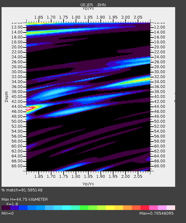
| Estimated Moho Depth: |
44.75 km |
| Estimated Crust Vp/Vs: |
1.60 |
| Assumed Crust Vp: |
6.391 km/s |
| Estimated Crust Vs: |
3.994 km/s |
| Estimated Crust Poisson's Ratio: |
0.18 |
|
| Radial Match: |
91.595146 % |
| Radial Bump: |
400 |
| Transverse Match: |
91.99588 % |
| Transverse Bump: |
400 |
| SOD ConfigId: |
6273 |
| Insert Time: |
2010-03-09 04:31:45.776 +0000 |
| GWidth: |
2.5 |
| Max Bumps: |
400 |
| Tol: |
0.001 |
|

Signal To Noise
| Channel | StoN | STA | LTA |
| GE:JER: :BHN:19971115T07:16:43.482996Z | 2.7123396 | 2.0685673E-7 | 7.626505E-8 |
| GE:JER: :BHE:19971115T07:16:43.482996Z | 2.031293 | 2.8685363E-7 | 1.4121727E-7 |
| GE:JER: :BHZ:19971115T07:16:43.482996Z | 13.384639 | 1.4506464E-6 | 1.08381435E-7 |
| Arrivals |
| Ps | 4.3 SECOND |
| PpPs | 18 SECOND |
| PsPs/PpSs | 22 SECOND |


