You are here: Home > Network List > GE - GEOFON Stations List
> Station JER GII Station Jerusalem, Israel > Earthquake Result Viewer
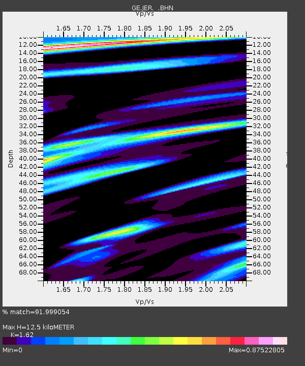
JER GII Station Jerusalem, Israel - Earthquake Result Viewer
| Earthquake location: |
Mindanao, Philippines |
| Earthquake latitude/longitude: |
8.1/123.7 |
| Earthquake time(UTC): |
1998/05/23 (143) 17:44:47 GMT |
| Earthquake Depth: |
658 km |
| Earthquake Magnitude: |
5.9 MB, 6.1 UNKNOWN, 6.0 MW |
| Earthquake Catalog/Contributor: |
WHDF/NEIC |
|
| Network: |
GE GEOFON |
| Station: |
JER GII Station Jerusalem, Israel |
| Lat/Lon: |
31.77 N/35.20 E |
| Elevation: |
770 m |
|
| Distance: |
84.5 deg |
| Az: |
301.202 deg |
| Baz: |
83.861 deg |
| Ray Param: |
0.043420654 |
| Estimated Moho Depth: |
12.5 km |
| Estimated Crust Vp/Vs: |
1.62 |
| Assumed Crust Vp: |
6.391 km/s |
| Estimated Crust Vs: |
3.945 km/s |
| Estimated Crust Poisson's Ratio: |
0.19 |
|
| Radial Match: |
91.999054 % |
| Radial Bump: |
400 |
| Transverse Match: |
92.569 % |
| Transverse Bump: |
400 |
| SOD ConfigId: |
4480 |
| Insert Time: |
2010-03-09 04:31:47.185 +0000 |
| GWidth: |
2.5 |
| Max Bumps: |
400 |
| Tol: |
0.001 |
|

Signal To Noise
| Channel | StoN | STA | LTA |
| GE:JER: :BHN:19980523T17:55:42.442004Z | 18.3431 | 1.9608638E-6 | 1.0689926E-7 |
| GE:JER: :BHE:19980523T17:55:42.442004Z | 1.4976605 | 1.02160016E-7 | 6.821307E-8 |
| GE:JER: :BHZ:19980523T17:55:42.442004Z | 3.539193 | 4.2825155E-7 | 1.210026E-7 |
| Arrivals |
| Ps | 1.2 SECOND |
| PpPs | 5.0 SECOND |
| PsPs/PpSs | 6.2 SECOND |


