You are here: Home > Network List > GE - GEOFON Stations List
> Station JER GII Station Jerusalem, Israel > Earthquake Result Viewer
JER GII Station Jerusalem, Israel - Earthquake Result Viewer
| Earthquake location: |
Luzon, Philippines |
| Earthquake latitude/longitude: |
14.7/120.0 |
| Earthquake time(UTC): |
1998/08/23 (235) 05:36:12 GMT |
| Earthquake Depth: |
70 km |
| Earthquake Magnitude: |
6.1 MB, 6.1 UNKNOWN, 6.0 MW |
| Earthquake Catalog/Contributor: |
WHDF/NEIC |
|
| Network: |
GE GEOFON |
| Station: |
JER GII Station Jerusalem, Israel |
| Lat/Lon: |
31.77 N/35.20 E |
| Elevation: |
770 m |
|
| Distance: |
78.1 deg |
| Az: |
299.9 deg |
| Baz: |
80.042 deg |
| Ray Param: |
0.049722403 |
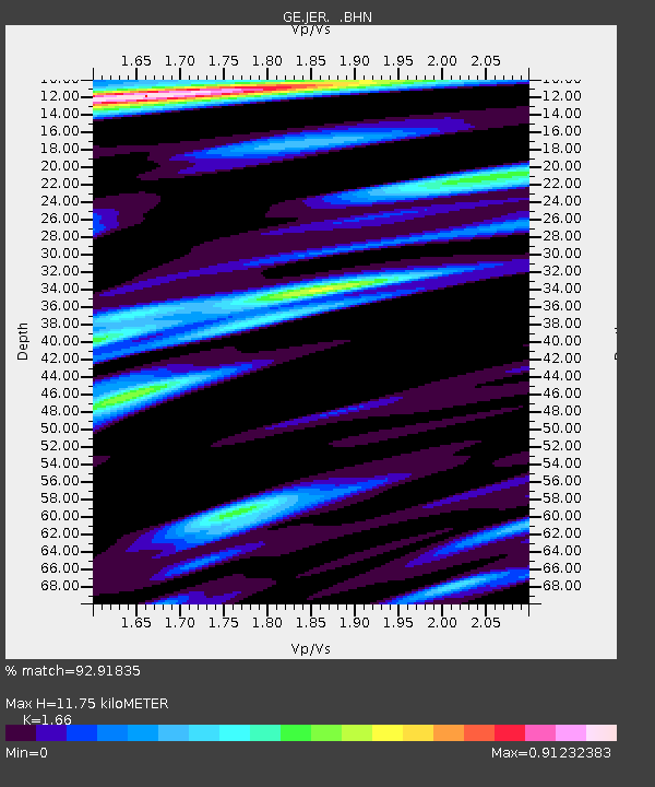
| Estimated Moho Depth: |
11.75 km |
| Estimated Crust Vp/Vs: |
1.66 |
| Assumed Crust Vp: |
6.391 km/s |
| Estimated Crust Vs: |
3.85 km/s |
| Estimated Crust Poisson's Ratio: |
0.22 |
|
| Radial Match: |
92.91835 % |
| Radial Bump: |
400 |
| Transverse Match: |
91.63988 % |
| Transverse Bump: |
400 |
| SOD ConfigId: |
4480 |
| Insert Time: |
2010-03-09 04:31:53.782 +0000 |
| GWidth: |
2.5 |
| Max Bumps: |
400 |
| Tol: |
0.001 |
|

Signal To Noise
| Channel | StoN | STA | LTA |
| GE:JER: :BHN:19980823T05:47:33.256018Z | 11.317896 | 2.8554202E-6 | 2.522925E-7 |
| GE:JER: :BHE:19980823T05:47:33.256018Z | 1.368663 | 1.9254539E-7 | 1.4068137E-7 |
| GE:JER: :BHZ:19980823T05:47:33.256018Z | 2.9787757 | 6.5770905E-7 | 2.2079846E-7 |
| Arrivals |
| Ps | 1.3 SECOND |
| PpPs | 4.7 SECOND |
| PsPs/PpSs | 6.0 SECOND |


