You are here: Home > Network List > GE - GEOFON Stations List
> Station JER GII Station Jerusalem, Israel > Earthquake Result Viewer
JER GII Station Jerusalem, Israel - Earthquake Result Viewer
| Earthquake location: |
Southern Molucca Sea |
| Earthquake latitude/longitude: |
-0.2/125.0 |
| Earthquake time(UTC): |
1998/08/28 (240) 12:40:58 GMT |
| Earthquake Depth: |
66 km |
| Earthquake Magnitude: |
6.2 MB, 6.1 UNKNOWN, 6.1 MW |
| Earthquake Catalog/Contributor: |
WHDF/NEIC |
|
| Network: |
GE GEOFON |
| Station: |
JER GII Station Jerusalem, Israel |
| Lat/Lon: |
31.77 N/35.20 E |
| Elevation: |
770 m |
|
| Distance: |
89.9 deg |
| Az: |
301.6 deg |
| Baz: |
90.224 deg |
| Ray Param: |
0.041698243 |
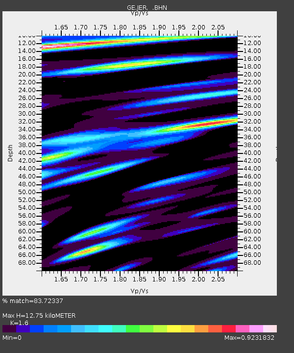
| Estimated Moho Depth: |
12.75 km |
| Estimated Crust Vp/Vs: |
1.60 |
| Assumed Crust Vp: |
6.391 km/s |
| Estimated Crust Vs: |
3.994 km/s |
| Estimated Crust Poisson's Ratio: |
0.18 |
|
| Radial Match: |
83.72337 % |
| Radial Bump: |
400 |
| Transverse Match: |
80.92767 % |
| Transverse Bump: |
400 |
| SOD ConfigId: |
4480 |
| Insert Time: |
2010-03-09 04:31:56.257 +0000 |
| GWidth: |
2.5 |
| Max Bumps: |
400 |
| Tol: |
0.001 |
|

Signal To Noise
| Channel | StoN | STA | LTA |
| GE:JER: :BHN:19980828T12:53:19.405017Z | 10.655883 | 1.2770344E-6 | 1.1984314E-7 |
| GE:JER: :BHE:19980828T12:53:19.405017Z | 1.2569636 | 1.1479723E-7 | 9.1329E-8 |
| GE:JER: :BHZ:19980828T12:53:19.405017Z | 2.279282 | 3.016283E-7 | 1.3233478E-7 |
| Arrivals |
| Ps | 1.2 SECOND |
| PpPs | 5.1 SECOND |
| PsPs/PpSs | 6.3 SECOND |


