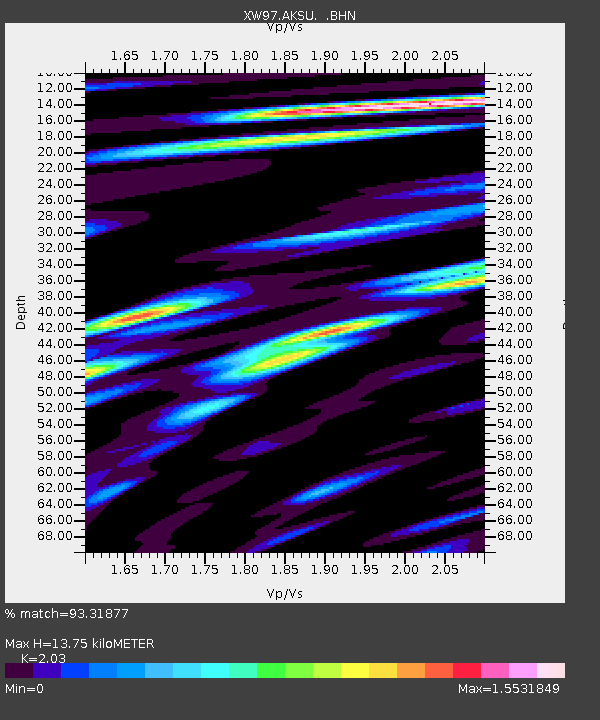
AKSU XW.AKSU - Earthquake Result Viewer

Earthquake location: Southern Sumatra, Indonesia
Earthquake latitude/longitude: -5.6/102.9
Earthquake time(UTC): 2000/06/05 (157) 03:00:26 GMT
Earthquake Depth: 33 km
Earthquake Magnitude: 5.5 MB, 5.5 MS, 5.8 MW, 5.8 MW
Earthquake Catalog/Contributor: WHDF/NEIC
Network: XW Tien Shan Continental Dynamics
Station: AKSU XW.AKSU
Lat/Lon: 41.14 N/80.11 E
Elevation: 1109 m
Distance: 51.0 deg
Az: 337.896 deg
Baz: 150.273 deg
Ray Param: 0.06763473
Estimated Moho Depth: 13.75 km
Estimated Crust Vp/Vs: 2.03
Assumed Crust Vp: 6.129 km/s
Estimated Crust Vs: 3.019 km/s
Estimated Crust Poisson's Ratio: 0.34
Radial Match: 93.31877 %
Radial Bump: 400
Transverse Match: 79.23872 %
Transverse Bump: 400
SOD ConfigId: 20082
Insert Time: 2010-02-26 15:14:19.122 +0000
GWidth: 2.5
Max Bumps: 400
Tol: 0.001

Signal To Noise

ChannelStoNSTALTA
XW:AKSU: :BHN:20000605T03:08:54.898009Z8.7403653.345565E-73.8277175E-8
XW:AKSU: :BHE:20000605T03:08:54.898009Z4.8511221.9600056E-74.0403137E-8
XW:AKSU: :BHZ:20000605T03:08:54.898009Z13.6207926.1030136E-74.4806598E-8
Arrivals
Ps2.4 SECOND
PpPs6.5 SECOND
PsPs/PpSs8.9 SECOND