You are here: Home > Network List > UW - Pacific Northwest Regional Seismic Network Stations List
> Station HOOD Mt Hood Meadows, OR CREST BB SMO > Earthquake Result Viewer
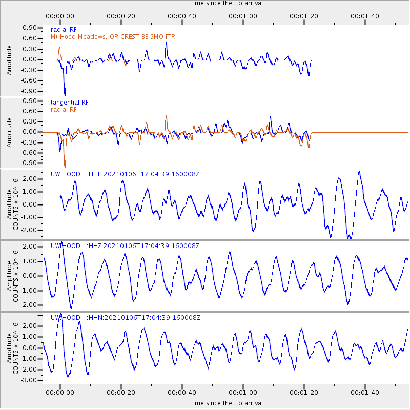
HOOD Mt Hood Meadows, OR CREST BB SMO - Earthquake Result Viewer
*The percent match for this event was below the threshold and hence no stack was calculated.
| Earthquake location: |
Solomon Islands |
| Earthquake latitude/longitude: |
-7.0/155.8 |
| Earthquake time(UTC): |
2021/01/06 (006) 16:52:17 GMT |
| Earthquake Depth: |
48 km |
| Earthquake Magnitude: |
5.8 Mww |
| Earthquake Catalog/Contributor: |
NEIC PDE/us |
|
| Network: |
UW Pacific Northwest Regional Seismic Network |
| Station: |
HOOD Mt Hood Meadows, OR CREST BB SMO |
| Lat/Lon: |
45.32 N/121.65 W |
| Elevation: |
1520 m |
|
| Distance: |
89.7 deg |
| Az: |
44.391 deg |
| Baz: |
259.811 deg |
| Ray Param: |
$rayparam |
*The percent match for this event was below the threshold and hence was not used in the summary stack. |
|
| Radial Match: |
73.60993 % |
| Radial Bump: |
400 |
| Transverse Match: |
53.896545 % |
| Transverse Bump: |
400 |
| SOD ConfigId: |
23341671 |
| Insert Time: |
2021-01-20 18:08:07.311 +0000 |
| GWidth: |
2.5 |
| Max Bumps: |
400 |
| Tol: |
0.001 |
|
Signal To Noise
| Channel | StoN | STA | LTA |
| UW:HOOD: :HHZ:20210106T17:04:39.160008Z | 2.083093 | 1.4517692E-6 | 6.9692965E-7 |
| UW:HOOD: :HHN:20210106T17:04:39.160008Z | 2.0252972 | 2.0549176E-6 | 1.0146252E-6 |
| UW:HOOD: :HHE:20210106T17:04:39.160008Z | 0.85462433 | 6.9322067E-7 | 8.111408E-7 |
| Arrivals |
| Ps | |
| PpPs | |
| PsPs/PpSs | |


