You are here: Home > Network List > GE - GEOFON Stations List
> Station JER GII Station Jerusalem, Israel > Earthquake Result Viewer
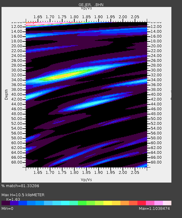
JER GII Station Jerusalem, Israel - Earthquake Result Viewer
| Earthquake location: |
Iceland |
| Earthquake latitude/longitude: |
64.0/-20.8 |
| Earthquake time(UTC): |
2000/06/21 (173) 00:51:46 GMT |
| Earthquake Depth: |
10 km |
| Earthquake Magnitude: |
6.1 MB, 6.6 MS, 6.5 MW, 6.4 MW |
| Earthquake Catalog/Contributor: |
WHDF/NEIC |
|
| Network: |
GE GEOFON |
| Station: |
JER GII Station Jerusalem, Israel |
| Lat/Lon: |
31.77 N/35.20 E |
| Elevation: |
770 m |
|
| Distance: |
47.1 deg |
| Az: |
105.584 deg |
| Baz: |
330.078 deg |
| Ray Param: |
0.07020751 |
| Estimated Moho Depth: |
10.5 km |
| Estimated Crust Vp/Vs: |
1.63 |
| Assumed Crust Vp: |
6.391 km/s |
| Estimated Crust Vs: |
3.921 km/s |
| Estimated Crust Poisson's Ratio: |
0.20 |
|
| Radial Match: |
81.33286 % |
| Radial Bump: |
400 |
| Transverse Match: |
63.93747 % |
| Transverse Bump: |
389 |
| SOD ConfigId: |
3744 |
| Insert Time: |
2010-03-09 04:32:36.778 +0000 |
| GWidth: |
2.5 |
| Max Bumps: |
400 |
| Tol: |
0.001 |
|

Signal To Noise
| Channel | StoN | STA | LTA |
| GE:JER: :BHN:20000621T00:59:48.080012Z | 2.219789 | 3.6114568E-7 | 1.6269371E-7 |
| GE:JER: :BHE:20000621T00:59:48.080012Z | 1.0229936 | 2.2722172E-7 | 2.2211452E-7 |
| GE:JER: :BHZ:20000621T00:59:48.080012Z | 2.584216 | 7.576387E-7 | 2.931793E-7 |
| Arrivals |
| Ps | 1.1 SECOND |
| PpPs | 4.0 SECOND |
| PsPs/PpSs | 5.1 SECOND |


