You are here: Home > Network List > IU - Global Seismograph Network (GSN - IRIS/USGS) Stations List
> Station PMG Port Moresby, New Guinea > Earthquake Result Viewer
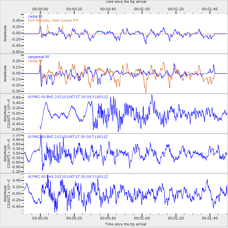
PMG Port Moresby, New Guinea - Earthquake Result Viewer
*The percent match for this event was below the threshold and hence no stack was calculated.
| Earthquake location: |
Southern Sumatra, Indonesia |
| Earthquake latitude/longitude: |
-4.4/102.7 |
| Earthquake time(UTC): |
2021/01/06 (006) 17:28:35 GMT |
| Earthquake Depth: |
65 km |
| Earthquake Magnitude: |
5.5 Mww |
| Earthquake Catalog/Contributor: |
NEIC PDE/us |
|
| Network: |
IU Global Seismograph Network (GSN - IRIS/USGS) |
| Station: |
PMG Port Moresby, New Guinea |
| Lat/Lon: |
9.40 S/147.16 E |
| Elevation: |
90 m |
|
| Distance: |
44.4 deg |
| Az: |
98.945 deg |
| Baz: |
273.374 deg |
| Ray Param: |
$rayparam |
*The percent match for this event was below the threshold and hence was not used in the summary stack. |
|
| Radial Match: |
66.1903 % |
| Radial Bump: |
400 |
| Transverse Match: |
64.77395 % |
| Transverse Bump: |
400 |
| SOD ConfigId: |
23341671 |
| Insert Time: |
2021-01-20 18:33:50.871 +0000 |
| GWidth: |
2.5 |
| Max Bumps: |
400 |
| Tol: |
0.001 |
|
Signal To Noise
| Channel | StoN | STA | LTA |
| IU:PMG:00:BHZ:20210106T17:36:09.519011Z | 2.122065 | 5.7806983E-7 | 2.7240912E-7 |
| IU:PMG:00:BH1:20210106T17:36:09.519011Z | 2.1844175 | 2.282421E-7 | 1.0448648E-7 |
| IU:PMG:00:BH2:20210106T17:36:09.519011Z | 1.8337756 | 3.5792024E-7 | 1.9518214E-7 |
| Arrivals |
| Ps | |
| PpPs | |
| PsPs/PpSs | |


