You are here: Home > Network List > GE - GEOFON Stations List
> Station JER GII Station Jerusalem, Israel > Earthquake Result Viewer
JER GII Station Jerusalem, Israel - Earthquake Result Viewer
| Earthquake location: |
Southeast Of Honshu, Japan |
| Earthquake latitude/longitude: |
30.5/137.7 |
| Earthquake time(UTC): |
2000/06/09 (161) 22:35:13 GMT |
| Earthquake Depth: |
473 km |
| Earthquake Magnitude: |
5.4 MB, 5.9 MW, 5.8 MW |
| Earthquake Catalog/Contributor: |
WHDF/NEIC |
|
| Network: |
GE GEOFON |
| Station: |
JER GII Station Jerusalem, Israel |
| Lat/Lon: |
31.77 N/35.20 E |
| Elevation: |
770 m |
|
| Distance: |
83.9 deg |
| Az: |
303.254 deg |
| Baz: |
57.959 deg |
| Ray Param: |
0.04450789 |
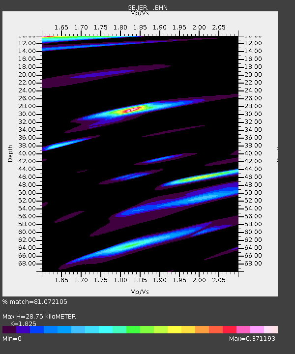
| Estimated Moho Depth: |
28.75 km |
| Estimated Crust Vp/Vs: |
1.83 |
| Assumed Crust Vp: |
6.391 km/s |
| Estimated Crust Vs: |
3.502 km/s |
| Estimated Crust Poisson's Ratio: |
0.29 |
|
| Radial Match: |
81.072105 % |
| Radial Bump: |
400 |
| Transverse Match: |
88.61645 % |
| Transverse Bump: |
400 |
| SOD ConfigId: |
3753 |
| Insert Time: |
2010-03-09 04:32:41.700 +0000 |
| GWidth: |
2.5 |
| Max Bumps: |
400 |
| Tol: |
0.001 |
|

Signal To Noise
| Channel | StoN | STA | LTA |
| GE:JER: :BHN:20000609T22:46:22.030Z | 1.0084953 | 8.145558E-8 | 8.076942E-8 |
| GE:JER: :BHE:20000609T22:46:22.030Z | 1.3046303 | 1.7836038E-7 | 1.3671335E-7 |
| GE:JER: :BHZ:20000609T22:46:22.030Z | 5.574609 | 7.553488E-7 | 1.3549808E-7 |
| Arrivals |
| Ps | 3.8 SECOND |
| PpPs | 12 SECOND |
| PsPs/PpSs | 16 SECOND |


