You are here: Home > Network List > GE - GEOFON Stations List
> Station JER GII Station Jerusalem, Israel > Earthquake Result Viewer
JER GII Station Jerusalem, Israel - Earthquake Result Viewer
| Earthquake location: |
Java Sea |
| Earthquake latitude/longitude: |
-5.7/110.8 |
| Earthquake time(UTC): |
1997/07/11 (192) 09:55:12 GMT |
| Earthquake Depth: |
574 km |
| Earthquake Magnitude: |
5.6 MB |
| Earthquake Catalog/Contributor: |
WHDF/NEIC |
|
| Network: |
GE GEOFON |
| Station: |
JER GII Station Jerusalem, Israel |
| Lat/Lon: |
31.77 N/35.20 E |
| Elevation: |
770 m |
|
| Distance: |
80.8 deg |
| Az: |
303.32 deg |
| Baz: |
102.5 deg |
| Ray Param: |
0.04625928 |
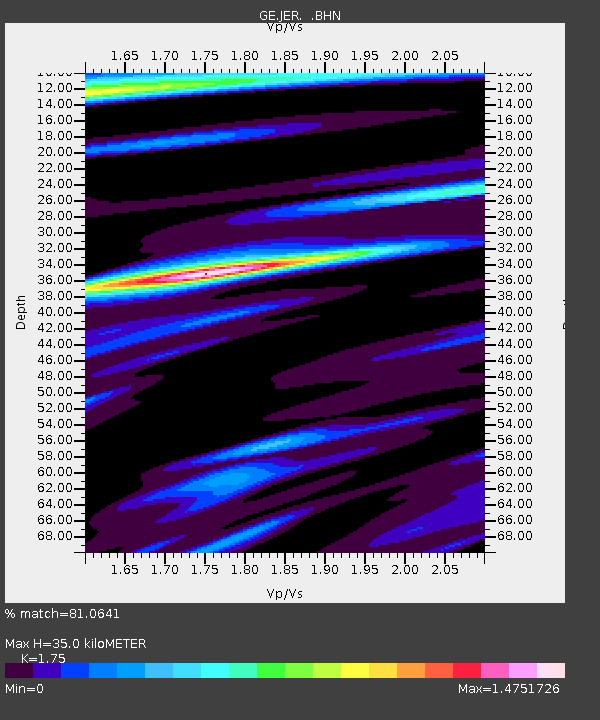
| Estimated Moho Depth: |
35.0 km |
| Estimated Crust Vp/Vs: |
1.75 |
| Assumed Crust Vp: |
6.391 km/s |
| Estimated Crust Vs: |
3.652 km/s |
| Estimated Crust Poisson's Ratio: |
0.26 |
|
| Radial Match: |
81.0641 % |
| Radial Bump: |
400 |
| Transverse Match: |
82.184715 % |
| Transverse Bump: |
400 |
| SOD ConfigId: |
4480 |
| Insert Time: |
2010-03-09 04:32:48.343 +0000 |
| GWidth: |
2.5 |
| Max Bumps: |
400 |
| Tol: |
0.001 |
|

Signal To Noise
| Channel | StoN | STA | LTA |
| GE:JER: :BHN:19970711T10:05:56.020996Z | 11.812911 | 2.127537E-6 | 1.8010269E-7 |
| GE:JER: :BHE:19970711T10:05:56.020996Z | 1.855099 | 2.444908E-7 | 1.3179394E-7 |
| GE:JER: :BHZ:19970711T10:05:56.020996Z | 3.83796 | 5.507538E-7 | 1.435017E-7 |
| Arrivals |
| Ps | 4.2 SECOND |
| PpPs | 15 SECOND |
| PsPs/PpSs | 19 SECOND |


