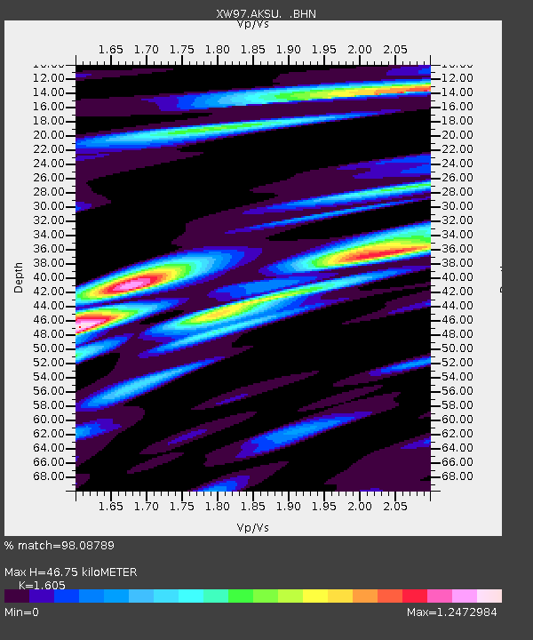
AKSU XW.AKSU - Earthquake Result Viewer
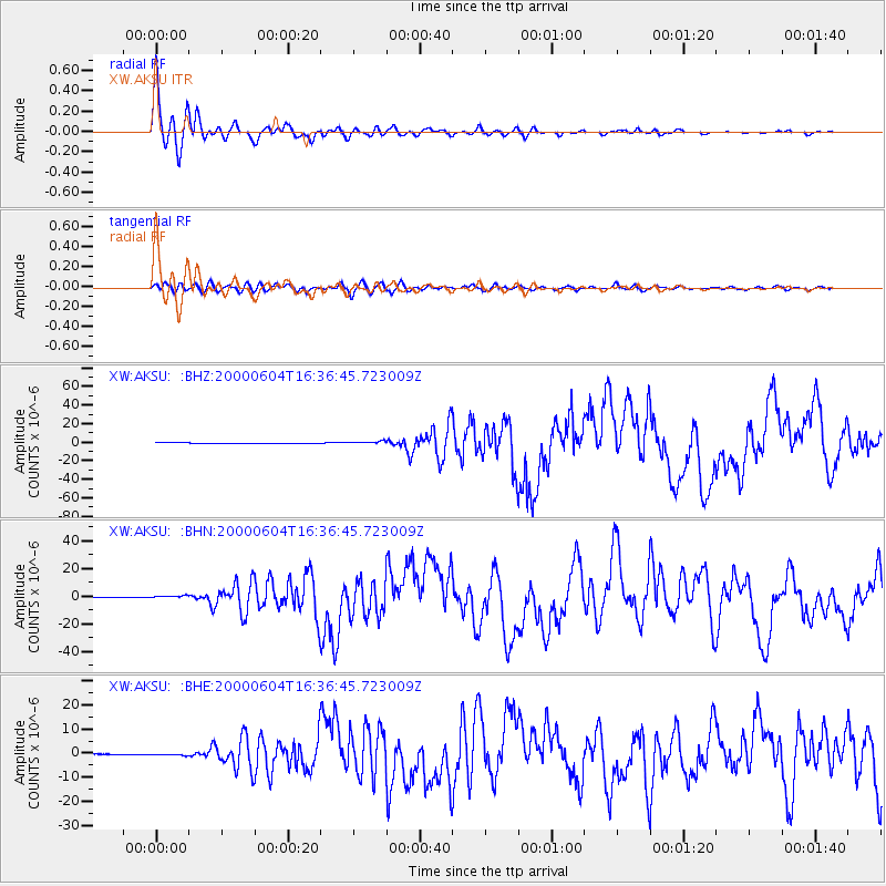
Earthquake location: Southern Sumatra, Indonesia
Earthquake latitude/longitude: -4.7/102.1
Earthquake time(UTC): 2000/06/04 (156) 16:28:26 GMT
Earthquake Depth: 33 km
Earthquake Magnitude: 6.8 MB, 8.0 MS, 7.9 MW, 7.7 MW
Earthquake Catalog/Contributor: WHDF/NEIC
Network: XW Tien Shan Continental Dynamics
Station: AKSU XW.AKSU
Lat/Lon: 41.14 N/80.11 E
Elevation: 1109 m
Distance: 49.9 deg
Az: 338.307 deg
Baz: 150.806 deg
Ray Param: 0.068359196
Estimated Moho Depth: 46.75 km
Estimated Crust Vp/Vs: 1.61
Assumed Crust Vp: 6.129 km/s
Estimated Crust Vs: 3.819 km/s
Estimated Crust Poisson's Ratio: 0.18
Radial Match: 98.08789 %
Radial Bump: 372
Transverse Match: 84.92426 %
Transverse Bump: 400
SOD ConfigId: 20082
Insert Time: 2010-02-26 15:14:20.001 +0000
GWidth: 2.5
Max Bumps: 400
Tol: 0.001

Signal To Noise

ChannelStoNSTALTA
XW:AKSU: :BHN:20000604T16:36:45.723009Z3.34989337.888609E-72.3548837E-7
XW:AKSU: :BHE:20000604T16:36:45.723009Z3.64237713.347151E-79.1894684E-8
XW:AKSU: :BHZ:20000604T16:36:45.723009Z6.7295861.4319513E-62.1278446E-7
Arrivals
Ps4.9 SECOND
PpPs19 SECOND
PsPs/PpSs24 SECOND