You are here: Home > Network List > GE - GEOFON Stations List
> Station JER GII Station Jerusalem, Israel > Earthquake Result Viewer
JER GII Station Jerusalem, Israel - Earthquake Result Viewer
| Earthquake location: |
Taiwan Region |
| Earthquake latitude/longitude: |
24.0/122.7 |
| Earthquake time(UTC): |
2001/12/18 (352) 04:02:58 GMT |
| Earthquake Depth: |
14 km |
| Earthquake Magnitude: |
6.3 MB, 7.3 MS, 6.9 MW, 6.8 MW |
| Earthquake Catalog/Contributor: |
WHDF/NEIC |
|
| Network: |
GE GEOFON |
| Station: |
JER GII Station Jerusalem, Israel |
| Lat/Lon: |
31.77 N/35.20 E |
| Elevation: |
770 m |
|
| Distance: |
75.8 deg |
| Az: |
298.634 deg |
| Baz: |
70.523 deg |
| Ray Param: |
0.051406056 |
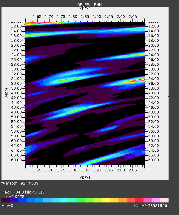
| Estimated Moho Depth: |
34.0 km |
| Estimated Crust Vp/Vs: |
2.10 |
| Assumed Crust Vp: |
6.391 km/s |
| Estimated Crust Vs: |
3.047 km/s |
| Estimated Crust Poisson's Ratio: |
0.35 |
|
| Radial Match: |
92.79839 % |
| Radial Bump: |
400 |
| Transverse Match: |
93.03614 % |
| Transverse Bump: |
400 |
| SOD ConfigId: |
20082 |
| Insert Time: |
2010-03-09 04:32:52.215 +0000 |
| GWidth: |
2.5 |
| Max Bumps: |
400 |
| Tol: |
0.001 |
|

Signal To Noise
| Channel | StoN | STA | LTA |
| GE:JER: :BHN:20011218T04:14:12.457002Z | 0.8916335 | 9.1326065E-8 | 1.0242556E-7 |
| GE:JER: :BHE:20011218T04:14:12.457002Z | 1.1445369 | 4.8650426E-9 | 4.2506647E-9 |
| GE:JER: :BHZ:20011218T04:14:12.457002Z | 5.6708837 | 5.946414E-7 | 1.04858685E-7 |
| Arrivals |
| Ps | 6.0 SECOND |
| PpPs | 16 SECOND |
| PsPs/PpSs | 22 SECOND |


