You are here: Home > Network List > G - GEOSCOPE Stations List
> Station FOMA Nahampoana reservation, Fort Dauphin, Madagascar > Earthquake Result Viewer
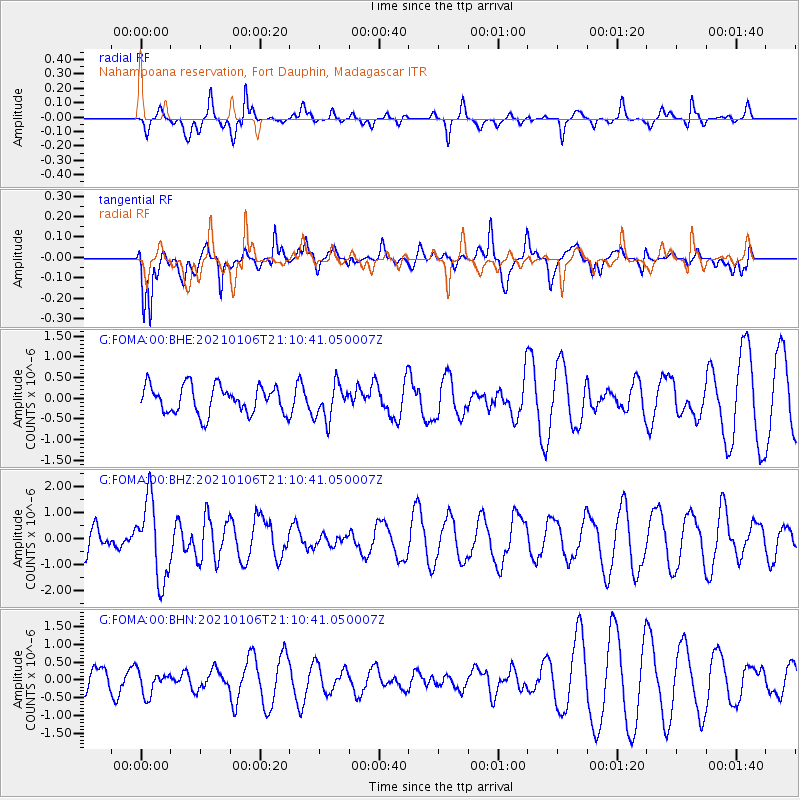
FOMA Nahampoana reservation, Fort Dauphin, Madagascar - Earthquake Result Viewer
*The percent match for this event was below the threshold and hence no stack was calculated.
| Earthquake location: |
Minahassa Peninsula, Sulawesi |
| Earthquake latitude/longitude: |
0.0/122.9 |
| Earthquake time(UTC): |
2021/01/06 (006) 20:59:35 GMT |
| Earthquake Depth: |
157 km |
| Earthquake Magnitude: |
6.1 mww |
| Earthquake Catalog/Contributor: |
NEIC PDE/us |
|
| Network: |
G GEOSCOPE |
| Station: |
FOMA Nahampoana reservation, Fort Dauphin, Madagascar |
| Lat/Lon: |
24.98 S/46.98 E |
| Elevation: |
26 m |
|
| Distance: |
77.3 deg |
| Az: |
244.499 deg |
| Baz: |
83.988 deg |
| Ray Param: |
$rayparam |
*The percent match for this event was below the threshold and hence was not used in the summary stack. |
|
| Radial Match: |
67.83875 % |
| Radial Bump: |
348 |
| Transverse Match: |
76.08138 % |
| Transverse Bump: |
400 |
| SOD ConfigId: |
23341671 |
| Insert Time: |
2021-01-20 22:04:25.282 +0000 |
| GWidth: |
2.5 |
| Max Bumps: |
400 |
| Tol: |
0.001 |
|
Signal To Noise
| Channel | StoN | STA | LTA |
| G:FOMA:00:BHZ:20210106T21:10:41.050007Z | 2.3795197 | 1.5073382E-6 | 6.3346323E-7 |
| G:FOMA:00:BHN:20210106T21:10:41.050007Z | 0.69746476 | 3.335477E-7 | 4.7822874E-7 |
| G:FOMA:00:BHE:20210106T21:10:41.050007Z | 1.265965 | 4.1966337E-7 | 3.314968E-7 |
| Arrivals |
| Ps | |
| PpPs | |
| PsPs/PpSs | |


