You are here: Home > Network List > G - GEOSCOPE Stations List
> Station KIP Kipapa, Hawai, U.S.A. (Pacific Ocean) > Earthquake Result Viewer
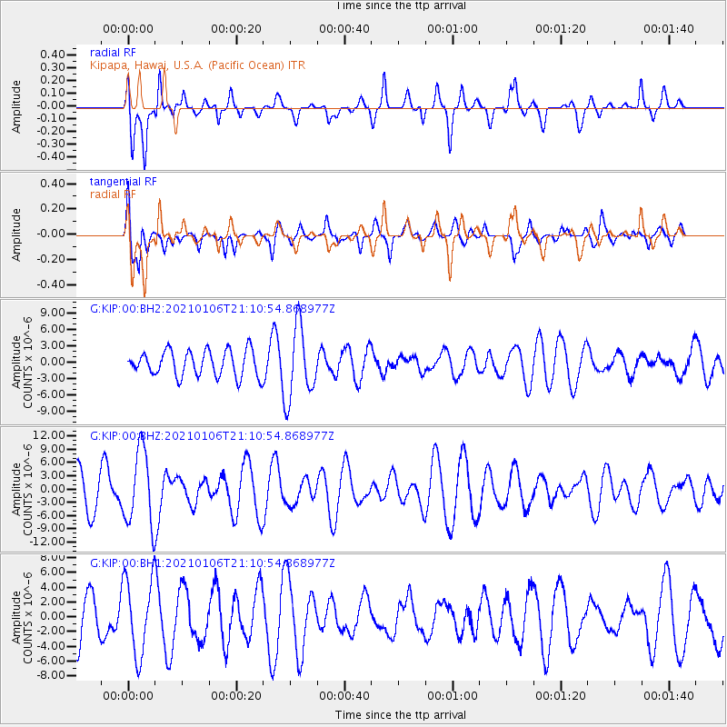
KIP Kipapa, Hawai, U.S.A. (Pacific Ocean) - Earthquake Result Viewer
*The percent match for this event was below the threshold and hence no stack was calculated.
| Earthquake location: |
Minahassa Peninsula, Sulawesi |
| Earthquake latitude/longitude: |
0.0/122.9 |
| Earthquake time(UTC): |
2021/01/06 (006) 20:59:35 GMT |
| Earthquake Depth: |
157 km |
| Earthquake Magnitude: |
6.1 mww |
| Earthquake Catalog/Contributor: |
NEIC PDE/us |
|
| Network: |
G GEOSCOPE |
| Station: |
KIP Kipapa, Hawai, U.S.A. (Pacific Ocean) |
| Lat/Lon: |
21.42 N/158.01 W |
| Elevation: |
70 m |
|
| Distance: |
79.8 deg |
| Az: |
68.352 deg |
| Baz: |
265.997 deg |
| Ray Param: |
$rayparam |
*The percent match for this event was below the threshold and hence was not used in the summary stack. |
|
| Radial Match: |
67.81362 % |
| Radial Bump: |
400 |
| Transverse Match: |
68.16302 % |
| Transverse Bump: |
400 |
| SOD ConfigId: |
23341671 |
| Insert Time: |
2021-01-20 22:04:28.943 +0000 |
| GWidth: |
2.5 |
| Max Bumps: |
400 |
| Tol: |
0.001 |
|
Signal To Noise
| Channel | StoN | STA | LTA |
| G:KIP:00:BHZ:20210106T21:10:54.868977Z | 1.9824529 | 8.6571845E-6 | 4.3669056E-6 |
| G:KIP:00:BH1:20210106T21:10:54.868977Z | 1.6237553 | 5.245402E-6 | 3.230414E-6 |
| G:KIP:00:BH2:20210106T21:10:54.868977Z | 2.8146756 | 6.6545426E-6 | 2.3642306E-6 |
| Arrivals |
| Ps | |
| PpPs | |
| PsPs/PpSs | |


