You are here: Home > Network List > GE - GEOFON Stations List
> Station JER GII Station Jerusalem, Israel > Earthquake Result Viewer
JER GII Station Jerusalem, Israel - Earthquake Result Viewer
| Earthquake location: |
Kuril Islands |
| Earthquake latitude/longitude: |
44.1/148.1 |
| Earthquake time(UTC): |
2001/03/23 (082) 11:30:10 GMT |
| Earthquake Depth: |
33 km |
| Earthquake Magnitude: |
5.9 MB, 5.7 MS, 6.0 MW, 5.9 MW |
| Earthquake Catalog/Contributor: |
WHDF/NEIC |
|
| Network: |
GE GEOFON |
| Station: |
JER GII Station Jerusalem, Israel |
| Lat/Lon: |
31.77 N/35.20 E |
| Elevation: |
770 m |
|
| Distance: |
82.8 deg |
| Az: |
307.719 deg |
| Baz: |
42.024 deg |
| Ray Param: |
0.046567593 |
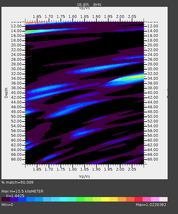
| Estimated Moho Depth: |
10.5 km |
| Estimated Crust Vp/Vs: |
1.64 |
| Assumed Crust Vp: |
6.391 km/s |
| Estimated Crust Vs: |
3.891 km/s |
| Estimated Crust Poisson's Ratio: |
0.21 |
|
| Radial Match: |
90.089 % |
| Radial Bump: |
400 |
| Transverse Match: |
91.354836 % |
| Transverse Bump: |
372 |
| SOD ConfigId: |
4714 |
| Insert Time: |
2010-03-09 04:33:03.964 +0000 |
| GWidth: |
2.5 |
| Max Bumps: |
400 |
| Tol: |
0.001 |
|

Signal To Noise
| Channel | StoN | STA | LTA |
| GE:JER: :BHN:20010323T11:42:00.386028Z | 2.2013717 | 2.5431947E-7 | 1.1552773E-7 |
| GE:JER: :BHE:20010323T11:42:00.386028Z | 2.0055509 | 2.9957704E-7 | 1.4937395E-7 |
| GE:JER: :BHZ:20010323T11:42:00.386028Z | 10.996413 | 2.1782273E-6 | 1.9808525E-7 |
| Arrivals |
| Ps | 1.1 SECOND |
| PpPs | 4.2 SECOND |
| PsPs/PpSs | 5.3 SECOND |


