You are here: Home > Network List > GE - GEOFON Stations List
> Station JER GII Station Jerusalem, Israel > Earthquake Result Viewer
JER GII Station Jerusalem, Israel - Earthquake Result Viewer
| Earthquake location: |
Mindanao, Philippines |
| Earthquake latitude/longitude: |
6.7/126.8 |
| Earthquake time(UTC): |
2001/01/02 (002) 07:30:03 GMT |
| Earthquake Depth: |
33 km |
| Earthquake Magnitude: |
5.8 MB, 6.2 MS, 6.4 MW, 6.3 MW |
| Earthquake Catalog/Contributor: |
WHDF/NEIC |
|
| Network: |
GE GEOFON |
| Station: |
JER GII Station Jerusalem, Israel |
| Lat/Lon: |
31.77 N/35.20 E |
| Elevation: |
770 m |
|
| Distance: |
87.9 deg |
| Az: |
301.572 deg |
| Baz: |
83.445 deg |
| Ray Param: |
0.04297507 |
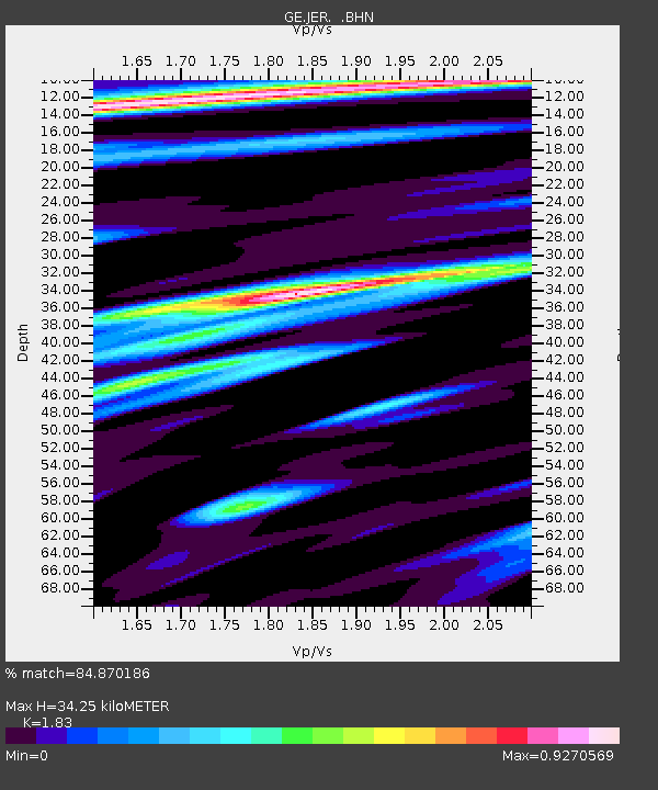
| Estimated Moho Depth: |
34.25 km |
| Estimated Crust Vp/Vs: |
1.83 |
| Assumed Crust Vp: |
6.391 km/s |
| Estimated Crust Vs: |
3.492 km/s |
| Estimated Crust Poisson's Ratio: |
0.29 |
|
| Radial Match: |
84.870186 % |
| Radial Bump: |
400 |
| Transverse Match: |
66.31707 % |
| Transverse Bump: |
400 |
| SOD ConfigId: |
3744 |
| Insert Time: |
2010-03-09 04:33:10.364 +0000 |
| GWidth: |
2.5 |
| Max Bumps: |
400 |
| Tol: |
0.001 |
|

Signal To Noise
| Channel | StoN | STA | LTA |
| GE:JER: :BHN:20010102T07:42:18.605012Z | 1.1802014 | 2.1467845E-7 | 1.8189984E-7 |
| GE:JER: :BHE:20010102T07:42:18.605012Z | 1.0806205 | 2.7214674E-7 | 2.5184303E-7 |
| GE:JER: :BHZ:20010102T07:42:18.605012Z | 3.2328773 | 8.4135866E-7 | 2.6025072E-7 |
| Arrivals |
| Ps | 4.5 SECOND |
| PpPs | 15 SECOND |
| PsPs/PpSs | 19 SECOND |


