You are here: Home > Network List > GE - GEOFON Stations List
> Station JER GII Station Jerusalem, Israel > Earthquake Result Viewer
JER GII Station Jerusalem, Israel - Earthquake Result Viewer
| Earthquake location: |
Java, Indonesia |
| Earthquake latitude/longitude: |
-7.9/110.2 |
| Earthquake time(UTC): |
2001/05/25 (145) 05:06:10 GMT |
| Earthquake Depth: |
143 km |
| Earthquake Magnitude: |
5.8 MB, 6.3 MW, 6.3 MW |
| Earthquake Catalog/Contributor: |
WHDF/NEIC |
|
| Network: |
GE GEOFON |
| Station: |
JER GII Station Jerusalem, Israel |
| Lat/Lon: |
31.77 N/35.20 E |
| Elevation: |
770 m |
|
| Distance: |
81.5 deg |
| Az: |
303.724 deg |
| Baz: |
104.662 deg |
| Ray Param: |
0.04718756 |
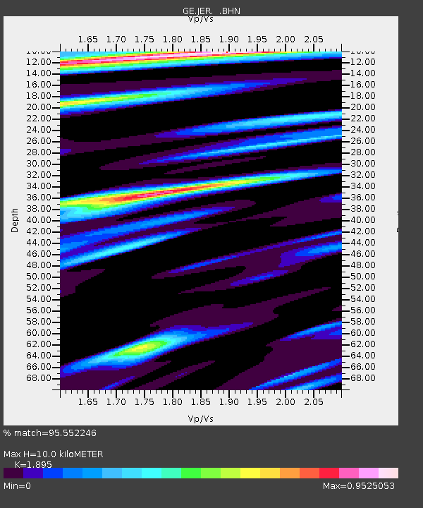
| Estimated Moho Depth: |
10.0 km |
| Estimated Crust Vp/Vs: |
1.89 |
| Assumed Crust Vp: |
6.391 km/s |
| Estimated Crust Vs: |
3.372 km/s |
| Estimated Crust Poisson's Ratio: |
0.31 |
|
| Radial Match: |
95.552246 % |
| Radial Bump: |
400 |
| Transverse Match: |
86.12208 % |
| Transverse Bump: |
400 |
| SOD ConfigId: |
4714 |
| Insert Time: |
2010-03-09 04:33:19.370 +0000 |
| GWidth: |
2.5 |
| Max Bumps: |
400 |
| Tol: |
0.001 |
|

Signal To Noise
| Channel | StoN | STA | LTA |
| GE:JER: :BHN:20010525T05:17:41.159004Z | 1.4412541 | 1.1314301E-7 | 7.850316E-8 |
| GE:JER: :BHE:20010525T05:17:41.159004Z | 2.6654725 | 2.75536E-7 | 1.03372294E-7 |
| GE:JER: :BHZ:20010525T05:17:41.159004Z | 8.755336 | 1.0128515E-6 | 1.1568391E-7 |
| Arrivals |
| Ps | 1.4 SECOND |
| PpPs | 4.4 SECOND |
| PsPs/PpSs | 5.9 SECOND |


