You are here: Home > Network List > GE - GEOFON Stations List
> Station JER GII Station Jerusalem, Israel > Earthquake Result Viewer
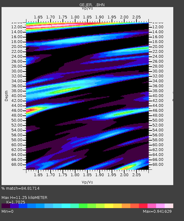
JER GII Station Jerusalem, Israel - Earthquake Result Viewer
| Earthquake location: |
Taiwan Region |
| Earthquake latitude/longitude: |
24.5/122.0 |
| Earthquake time(UTC): |
2001/06/14 (165) 02:35:25 GMT |
| Earthquake Depth: |
32 km |
| Earthquake Magnitude: |
5.7 MB, 5.6 MS, 5.9 MW, 5.9 MW |
| Earthquake Catalog/Contributor: |
WHDF/NEIC |
|
| Network: |
GE GEOFON |
| Station: |
JER GII Station Jerusalem, Israel |
| Lat/Lon: |
31.77 N/35.20 E |
| Elevation: |
770 m |
|
| Distance: |
75.0 deg |
| Az: |
298.3 deg |
| Baz: |
70.333 deg |
| Ray Param: |
0.051920675 |
| Estimated Moho Depth: |
11.25 km |
| Estimated Crust Vp/Vs: |
1.70 |
| Assumed Crust Vp: |
6.391 km/s |
| Estimated Crust Vs: |
3.754 km/s |
| Estimated Crust Poisson's Ratio: |
0.24 |
|
| Radial Match: |
84.81714 % |
| Radial Bump: |
400 |
| Transverse Match: |
82.96369 % |
| Transverse Bump: |
400 |
| SOD ConfigId: |
3753 |
| Insert Time: |
2010-03-09 04:33:22.952 +0000 |
| GWidth: |
2.5 |
| Max Bumps: |
400 |
| Tol: |
0.001 |
|

Signal To Noise
| Channel | StoN | STA | LTA |
| GE:JER: :BHN:20010614T02:46:32.914004Z | 1.436867 | 8.596666E-8 | 5.982924E-8 |
| GE:JER: :BHE:20010614T02:46:32.914004Z | 1.3895158 | 1.9225841E-7 | 1.383636E-7 |
| GE:JER: :BHZ:20010614T02:46:32.914004Z | 4.9696536 | 5.382826E-7 | 1.0831391E-7 |
| Arrivals |
| Ps | 1.3 SECOND |
| PpPs | 4.6 SECOND |
| PsPs/PpSs | 5.9 SECOND |


