You are here: Home > Network List > S1 - Australian Seismometers in Schools Stations List
> Station AUPHS Peel High School > Earthquake Result Viewer
AUPHS Peel High School - Earthquake Result Viewer
| Earthquake location: |
Minahassa Peninsula, Sulawesi |
| Earthquake latitude/longitude: |
0.0/122.9 |
| Earthquake time(UTC): |
2021/01/06 (006) 20:59:35 GMT |
| Earthquake Depth: |
157 km |
| Earthquake Magnitude: |
6.1 mww |
| Earthquake Catalog/Contributor: |
NEIC PDE/us |
|
| Network: |
S1 Australian Seismometers in Schools |
| Station: |
AUPHS Peel High School |
| Lat/Lon: |
31.10 S/150.89 E |
| Elevation: |
404 m |
|
| Distance: |
40.8 deg |
| Az: |
141.961 deg |
| Baz: |
314.082 deg |
| Ray Param: |
0.073618375 |
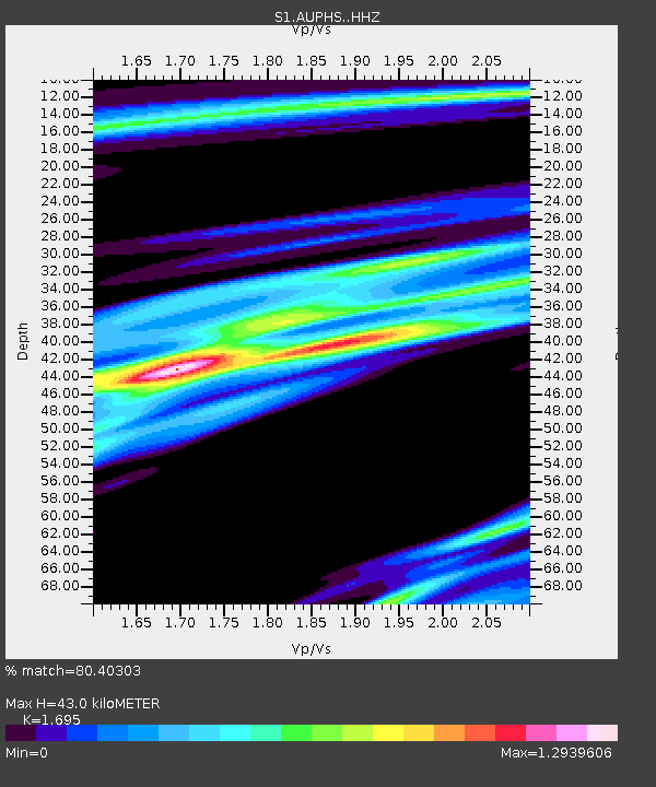
| Estimated Moho Depth: |
43.0 km |
| Estimated Crust Vp/Vs: |
1.70 |
| Assumed Crust Vp: |
6.577 km/s |
| Estimated Crust Vs: |
3.88 km/s |
| Estimated Crust Poisson's Ratio: |
0.23 |
|
| Radial Match: |
80.40303 % |
| Radial Bump: |
400 |
| Transverse Match: |
50.498184 % |
| Transverse Bump: |
400 |
| SOD ConfigId: |
23341671 |
| Insert Time: |
2021-01-20 22:07:58.190 +0000 |
| GWidth: |
2.5 |
| Max Bumps: |
400 |
| Tol: |
0.001 |
|

Signal To Noise
| Channel | StoN | STA | LTA |
| S1:AUPHS: :HHZ:20210106T21:06:30.21999Z | 6.01652 | 2.9737405E-6 | 4.942625E-7 |
| S1:AUPHS: :HHN:20210106T21:06:30.21999Z | 2.5278692 | 1.1884579E-6 | 4.7014214E-7 |
| S1:AUPHS: :HHE:20210106T21:06:30.21999Z | 2.2506418 | 1.3578477E-6 | 6.033158E-7 |
| Arrivals |
| Ps | 4.9 SECOND |
| PpPs | 16 SECOND |
| PsPs/PpSs | 21 SECOND |


