You are here: Home > Network List > TA - USArray Transportable Network (new EarthScope stations) Stations List
> Station F14K Arctic Creek, AK, USA > Earthquake Result Viewer
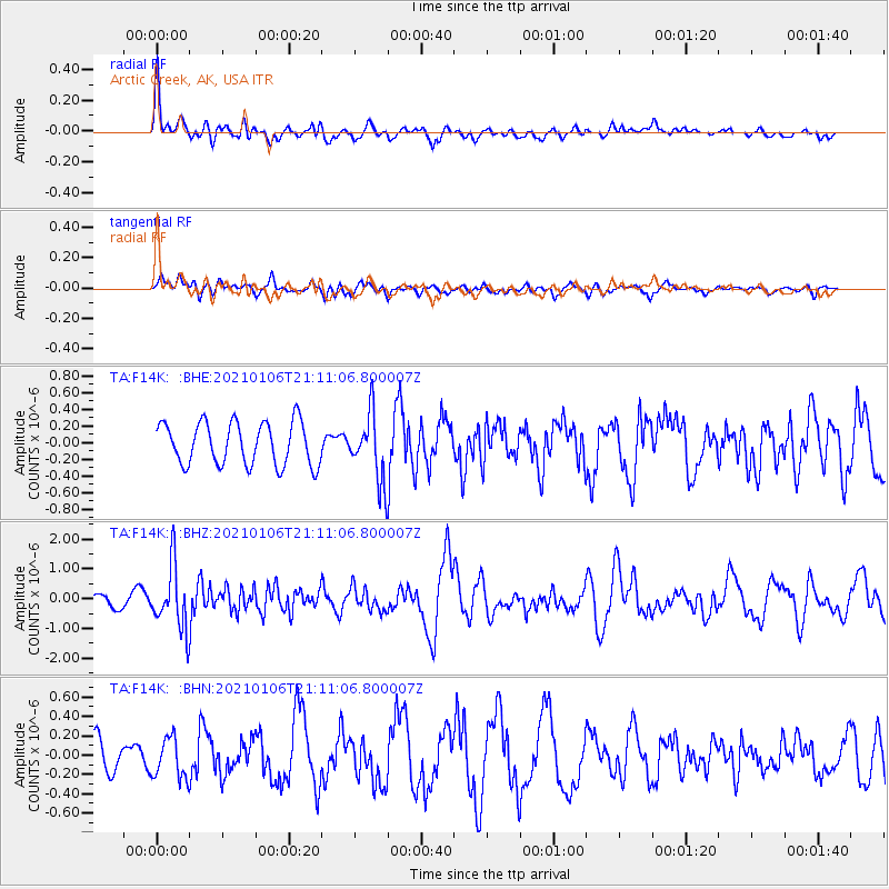
F14K Arctic Creek, AK, USA - Earthquake Result Viewer
*The percent match for this event was below the threshold and hence no stack was calculated.
| Earthquake location: |
Minahassa Peninsula, Sulawesi |
| Earthquake latitude/longitude: |
0.0/122.9 |
| Earthquake time(UTC): |
2021/01/06 (006) 20:59:35 GMT |
| Earthquake Depth: |
157 km |
| Earthquake Magnitude: |
6.1 mww |
| Earthquake Catalog/Contributor: |
NEIC PDE/us |
|
| Network: |
TA USArray Transportable Network (new EarthScope stations) |
| Station: |
F14K Arctic Creek, AK, USA |
| Lat/Lon: |
65.47 N/166.33 W |
| Elevation: |
266 m |
|
| Distance: |
82.1 deg |
| Az: |
23.445 deg |
| Baz: |
252.393 deg |
| Ray Param: |
$rayparam |
*The percent match for this event was below the threshold and hence was not used in the summary stack. |
|
| Radial Match: |
63.164173 % |
| Radial Bump: |
400 |
| Transverse Match: |
40.454422 % |
| Transverse Bump: |
400 |
| SOD ConfigId: |
23341671 |
| Insert Time: |
2021-01-20 22:08:13.244 +0000 |
| GWidth: |
2.5 |
| Max Bumps: |
400 |
| Tol: |
0.001 |
|
Signal To Noise
| Channel | StoN | STA | LTA |
| TA:F14K: :BHZ:20210106T21:11:06.800007Z | 3.3968093 | 1.0593911E-6 | 3.118783E-7 |
| TA:F14K: :BHN:20210106T21:11:06.800007Z | 1.1915615 | 2.0967866E-7 | 1.7596966E-7 |
| TA:F14K: :BHE:20210106T21:11:06.800007Z | 1.5749651 | 4.029228E-7 | 2.5582966E-7 |
| Arrivals |
| Ps | |
| PpPs | |
| PsPs/PpSs | |


