You are here: Home > Network List > TA - USArray Transportable Network (new EarthScope stations) Stations List
> Station I17K Unalakleet, AK, USA > Earthquake Result Viewer
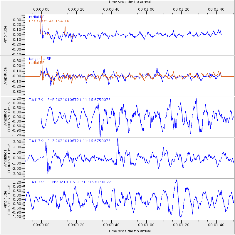
I17K Unalakleet, AK, USA - Earthquake Result Viewer
*The percent match for this event was below the threshold and hence no stack was calculated.
| Earthquake location: |
Minahassa Peninsula, Sulawesi |
| Earthquake latitude/longitude: |
0.0/122.9 |
| Earthquake time(UTC): |
2021/01/06 (006) 20:59:35 GMT |
| Earthquake Depth: |
157 km |
| Earthquake Magnitude: |
6.1 mww |
| Earthquake Catalog/Contributor: |
NEIC PDE/us |
|
| Network: |
TA USArray Transportable Network (new EarthScope stations) |
| Station: |
I17K Unalakleet, AK, USA |
| Lat/Lon: |
63.89 N/160.70 W |
| Elevation: |
105 m |
|
| Distance: |
84.0 deg |
| Az: |
25.623 deg |
| Baz: |
257.745 deg |
| Ray Param: |
$rayparam |
*The percent match for this event was below the threshold and hence was not used in the summary stack. |
|
| Radial Match: |
55.947235 % |
| Radial Bump: |
396 |
| Transverse Match: |
71.30699 % |
| Transverse Bump: |
315 |
| SOD ConfigId: |
23341671 |
| Insert Time: |
2021-01-20 22:08:30.294 +0000 |
| GWidth: |
2.5 |
| Max Bumps: |
400 |
| Tol: |
0.001 |
|
Signal To Noise
| Channel | StoN | STA | LTA |
| TA:I17K: :BHZ:20210106T21:11:16.675007Z | 3.796154 | 1.3634748E-6 | 3.5917267E-7 |
| TA:I17K: :BHN:20210106T21:11:16.675007Z | 0.5922803 | 1.5729697E-7 | 2.6557856E-7 |
| TA:I17K: :BHE:20210106T21:11:16.675007Z | 1.6070709 | 6.2738417E-7 | 3.9038983E-7 |
| Arrivals |
| Ps | |
| PpPs | |
| PsPs/PpSs | |


