You are here: Home > Network List > GE - GEOFON Stations List
> Station JER GII Station Jerusalem, Israel > Earthquake Result Viewer
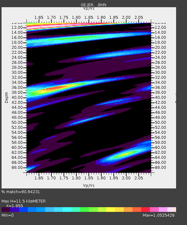
JER GII Station Jerusalem, Israel - Earthquake Result Viewer
| Earthquake location: |
India-Bangladesh Border Region |
| Earthquake latitude/longitude: |
22.2/92.7 |
| Earthquake time(UTC): |
1997/11/21 (325) 11:23:06 GMT |
| Earthquake Depth: |
54 km |
| Earthquake Magnitude: |
5.9 MB, 6.1 UNKNOWN, 6.1 MW |
| Earthquake Catalog/Contributor: |
WHDF/NEIC |
|
| Network: |
GE GEOFON |
| Station: |
JER GII Station Jerusalem, Israel |
| Lat/Lon: |
31.77 N/35.20 E |
| Elevation: |
770 m |
|
| Distance: |
51.6 deg |
| Az: |
293.582 deg |
| Baz: |
85.663 deg |
| Ray Param: |
0.06715661 |
| Estimated Moho Depth: |
11.5 km |
| Estimated Crust Vp/Vs: |
1.65 |
| Assumed Crust Vp: |
6.391 km/s |
| Estimated Crust Vs: |
3.861 km/s |
| Estimated Crust Poisson's Ratio: |
0.21 |
|
| Radial Match: |
90.94231 % |
| Radial Bump: |
400 |
| Transverse Match: |
76.502464 % |
| Transverse Bump: |
400 |
| SOD ConfigId: |
4480 |
| Insert Time: |
2010-03-09 04:33:26.930 +0000 |
| GWidth: |
2.5 |
| Max Bumps: |
400 |
| Tol: |
0.001 |
|

Signal To Noise
| Channel | StoN | STA | LTA |
| GE:JER: :BHN:19971121T11:31:36.733014Z | 1.3879267 | 2.0705255E-7 | 1.4918119E-7 |
| GE:JER: :BHE:19971121T11:31:36.733014Z | 1.020126 | 1.0162832E-7 | 9.9623314E-8 |
| GE:JER: :BHZ:19971121T11:31:36.733014Z | 0.88185245 | 1.2813035E-7 | 1.4529681E-7 |
| Arrivals |
| Ps | 1.3 SECOND |
| PpPs | 4.5 SECOND |
| PsPs/PpSs | 5.8 SECOND |


